 |
Margate before Sea bathing: 1300 to 1736
Anthony Lee
Chapter 1: The Town
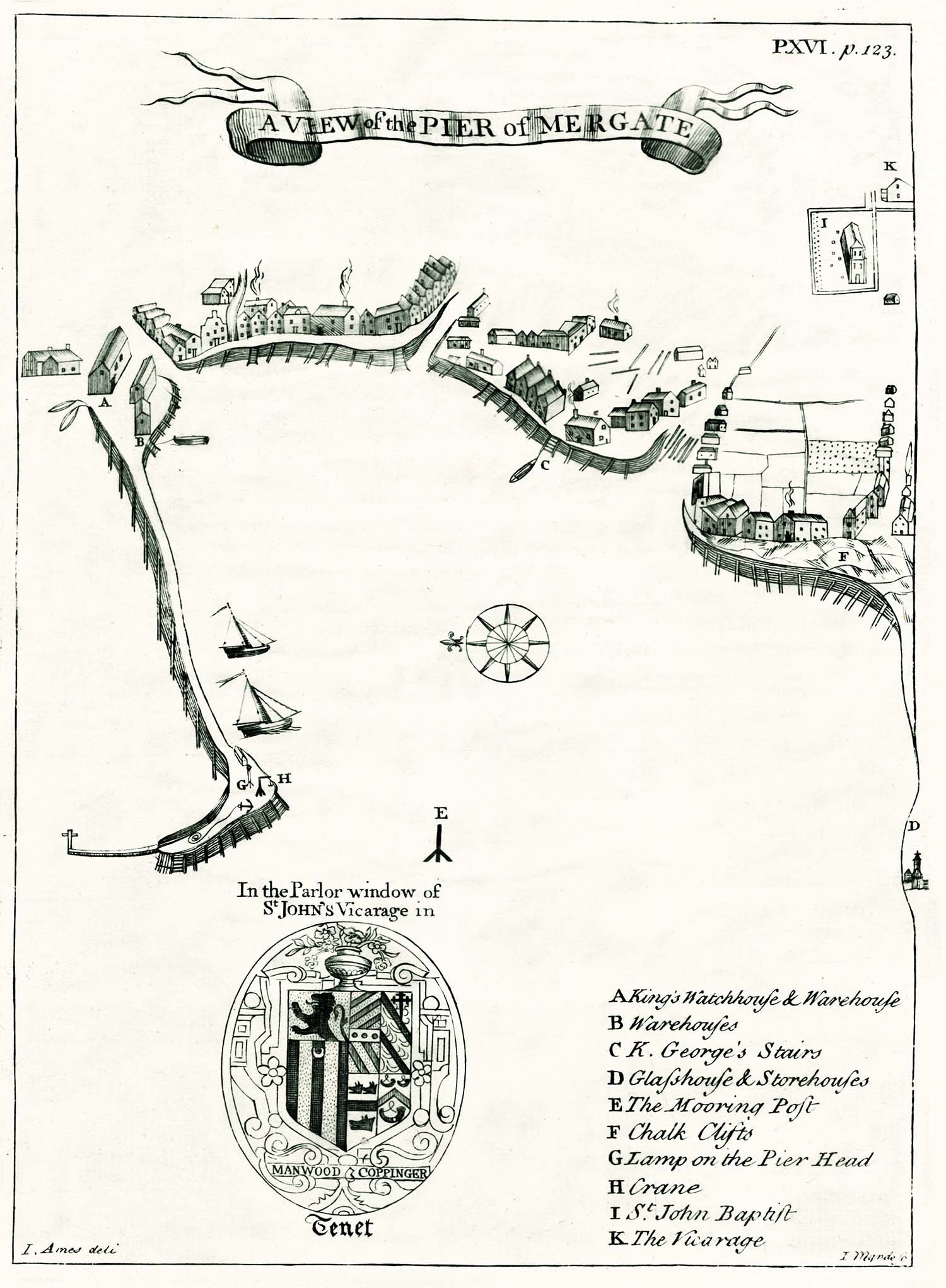 |
Figure 9. Margate in 1736, from John Lewis 'The History and antiquities as well ecclesiastical as civil, of the Isle of Tenet, in Kent', 2nd ed., 1736. |
We are lucky to have a good description of Margate in 1723 in the first edition of John Lewis’s The history and antiquities ecclesiastical and civil, of the Isle of Tenet, in Kent,1 and, in the second edition of 1736,2 a sketch map of the town (Figure 9) The map shows the harbour protected by a single curved pier designed to exclude winds and waves from the most dangerous direction, the north-east.3 The Pier was a simple box-like structure consisting of wooden piles, packed with anything available, including chalk, soil, flint, and sand;4 a stone structure would have been better able to withstand the winter storms, but there was no local source of stone. The harbour was dry at low water, and had to be entered with care at all times, as a long ledge of rock ran out from the West Cliff across the harbour mouth.3 Lewis described it as ‘a small harbor for ships of no great burden, and for fishing craft’.1 The story of the Pier is told in Chapter 2.
To the north of the harbour, and overlooking it, was the Fort. This was a simple earthwork with platforms for guns, with a watch-house ‘in which men watched with the Parish’s Arms, provided for that purpose’.1 The Fort, says John Lewis, was ‘not only a safeguard to the town, but a great means of preserving merchants ships, going round the North Foreland into the Downes, from the enemies privateers, which often lurk there about to snap up ships sailing that way, which cannot see them behind the land’.1 The Fort was later to become a popular place for visitors to meet and promenade, and is remembered in the name of the present Fort Hill. The history of the Fort is described in Chapter 6.
About half a mile from the harbour was the church of St John the Baptist. The church was first a chapel and then a dependency of St Mary’s Minster in Thanet.5 A chronicle compiled by Thorne, a monk of St Augustine’s Abbey in about 1380 records that in 1124 St Mary’s Minster and its chapels, including that of St John’s, were all assigned for the upkeep of St Augustine’s. The assignment was confirmed in 1182 and in 1237 St John’s acquired a perpetual chaplain. The Archdeacon’s visitations to St John’s in the sixteenth century record that the church was in a very poor state of repair at that time, the chancel without a proper roof and the vicarage in ruins (Chapter 5).7 Gradually, though, things improved and in 1769 the Church was described as:6
a large building of flints rough-cast, with the quoins, windows and door-cases of hewn stone. It has three isles, three chancels, and in the times of popery, there were three altars dedicated to St Anne, St John, and St George, and over them in niches stood the images of those saints. At the west end of the north isle stands the tower, which is square and low, with only a short spire on the top of it; and within this tower is a ring of five bells, the largest in the Island. Adjoining to the south side of the church yard, anciently stood two houses called the Wax-houses, where were made the wax lights used in the church, and at processions. The wax-houses burnt down in 1641.
In the fifteenth century a treasury was built on the north side of the church, ‘a square building of hewn stone with battlements, and a flat roof covered with lead’.1,5 At first this was used for the safe keeping of the church treasures but then became a general store-house for ‘gun-powder, shot, match, &c. for the use of the Fort’.1 In 1701 it was converted into a vestry, ‘and a chimney built’, presumably to keep those using the vestry warm in winter;1 the vestry was used to hold parish meetings and administer poor relief. The west end of the south aisle of the church was partitioned off and used as a schoolroom, probably in the sixteenth century.5
Lewis’s sketch map of Margate of 1736 shows how the town had developed around the bay (Figure 9). On the left of the map are the pier, the King’s Warehouse, and the other warehouses. To the right (marked C on the map) are King George’s Stairs, shown close to Horn Corner on Edmunds map of 1821, at the west end of what was to become the Marine Parade. Roughly midway between the landward end of the Pier and King George’s Stairs is an inlet corresponding to the remains of the old creek; by the time of Edmund’s map this had become Bridge Street, leading into King Street. Immediately to the west of King George’s stairs another inlet corresponds to the seaward end of the future Market Street. To the west of the inlet a road runs west a short way along the bay before turning inland and up the hill to the Church, corresponding to the present High Street. On the extreme right of the map, the ‘Glasshouse and Storehouses’ (D) probably correspond to a location west of the Brooks, around the position of Buenos Ayres in Edmund’s map. The Glasshouse is described in an advertisement from 1723: ‘There is now erecting in the Isle of Thanet a large Glass-house, with convenient store or warehouses for carrying on the Glass Trade, and the gentlemen concerned, propose, from the situation, to carry it on with less expense than attends those built about this City [London]’. 8 This scant information is all we have about the glass-house. It is not certain why it was felt that Margate was a suitable place for the glass trade but the key factor could have been the ready availability of kelp ash used in the manufacture of glass and produced by the burning of kelp (sea weed). The production of kelp ash for the glass industry was continued in Margate until the 19th century, in Alkali Row.9
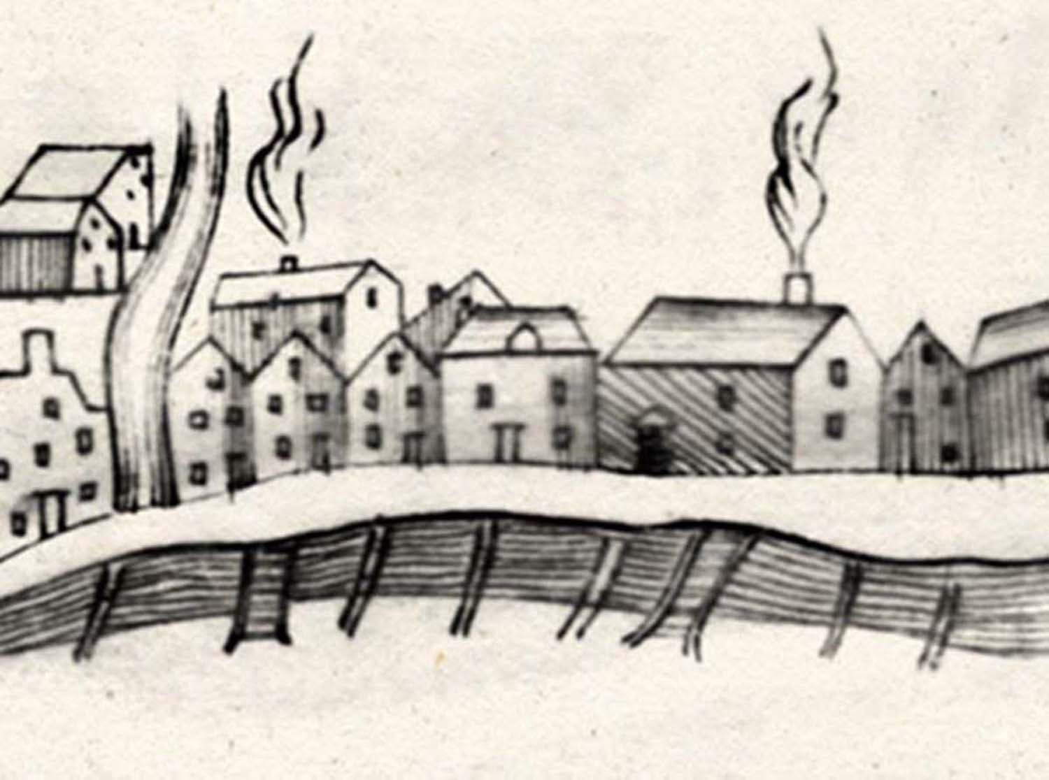 |
Figure 10. The wooden jetties protecting the shore line. Detail from Lewis’s map of Margate, 1736. |
 |
Figure 11. A view from the Pier at Margate. Watercolour by George Keate, 1779. The watercolour shows the crude wooden jetties along the shore line protecting the town from the sea. |
The larger of the Margate inns were concentrated close to the harbour, on what was to become the Parade and Bankside and, indeed, the largest of the buildings shown on Lewis’s map of the town are in this area. Unfortunately the early Parade was not a very attractive place, as made clear in the quotation already given from George Carry’s guide book of 1799.10 Lewis’s map (Figure 10) shows the simple piles of timber, the jetties, lining the shore and protecting the town from the sea; these jetties are also shown in early watercolours of the town such as that shown in Figure 11, dating from 1779. These jetties were frequently damaged by winter storms. For example, in 1691 the inhabitants of Margate petitioned parliament asking for financial help as ‘on the 10th and 13th days of October and the 8th of December last [1690], by the violent blowing of the north-west wind . . . that part of the town which is guarded by the pier and jetties, is so laid open that it is expected to be washed away if the wind should blow fresh at north-west’.11
 |
Figure 12. Detail from J. Hall’s map of the Isle of Thanet of 1777 showing the roads to Margate |
Two of the roads leading towards the harbour were referred to as the King’s Highway. One led from the Church to the harbour, and eventually became known as the High Street, a name first used in print in 1766, in an advertisement in a London newspaper for a property ‘situated at the upper end of High-street, near the Church in Margate’.12 The other King’s Highway, leading to the east end of the future Parade, was later known as King Street. Traffic going to and from Canterbury entered the Isle of Thanet at Sarre, and then, according to the season of the year, took either the summer or the winter road, the latter joining the former above Monkton, then passing through Acol, Hengrove, Twenties, Shottendane and Salmestone to join the first King’s Highway. In Harris’s map of 1717 (Figure 8) the junction between the road from Canterbury and the King’s Highway is at a point roughly half way between the harbour and the Church. However, in Hall’s map of 1777 (Figure 12) the road from Canterbury joins the King’s Highway at a point opposite the Church. It may be that the local roads were realigned at some period between the publication of these two maps to meet the needs of the holiday trade.
The King’s Highway leading from the Church to the harbour was narrow and winding. In A description of the Isle of Thanet published in 1765 the ‘Principal street’, as it was referred to, was described as being ‘built on an easy descent, by which means the upper part is clean and dry, but the lower end much otherwise’.13 Zechariah Cozens, in his Tour through the Isle of Thanet, published in 1793, says of the High-street that it was originally ‘but a long dirty lane, consisting chiefly of malt-houses, herring-hangs, and the poor little cottages of fishermen’.14 Malt-houses were buildings in which cereal grain, particularly barley, was converted into malt by soaking the grain in water, allowing it to sprout, and then drying it to stop further growth; the malt was used in brewing, and was either used locally or exported to London by hoy. A herring hang was a shed where the local herring catch was dried and smoked to preserve it. Malthouses and herring-hangs were important for the economy of Margate,1 but would hardly have added to the attractions of this, the principal road into Margate. As late as 1799 George Seville Carey was reporting in his The Balnea, an impartial description of all the popular Watering Places in England, that ‘there is no proper inlet to the town of Margate from any direction whatever; and what they call High-street is a close contracted thoroughfare; many parts of it filthy, with scarcely a decent habitation, and only serves in the present instance to show us what their now-flourishing town was in its original state. The street is too narrow for one carriage to pass another in the day, but in the night it is dangerous indeed!’10
The early history of the High Street is closely linked to the story of the Norwoods, a local family of prosperous yeomen with a long history described in detail in Peter Hill’s book Dane Court, St Peter’s in Thanet; what follows is taken largely from that book.15 In the parish of St John’s was the manor of Dene which, in the seventeenth century, was owned by the Norwood family; the Norwoods also owned Dane Court, a property in the parish of St Peter’s, not to be confused with the manor of Dene. The story of the Norwood family in Thanet starts with Richard Norwood who bought Dane Court in about 1520. On the death of Richard Norwood, Dane Court passed to his son Alexander who died in 1558. Alexander Norwood was described in a document of 1551 as ‘Baylif of Margate’ and another Norwood, William Norwood, was similarly described as being ‘portreeve of Margate’ in the sixteenth century.16,17 The exact meanings of the terms baylif and portreeve vary with time and place but generally a port-reeve is the bailiff of a port town and a port-reeve is the same as a Port warden,18 a position known in Margate as a Pier warden, a position of some authority and importance in the town.
In his will dated 1 January 1558 Alexander Norwood specified that at the time of his burial, ‘there be dispended and layde out . . . in the service of God, and to poore people’ the sum of 40 shillings. There was a further 40 shillings for similar purposes, and within one month of his death £20 was to be distributed to the poor of St John’s and St Peter’s ‘and in other deades of charitie, where moste neade shalbee’: in addition, he gave to ‘the poor of Margate all that mony that I have bestowed and layde out all redye’. His bequests included one to his son Valentine of ‘all such store of come [corn?], cattal and other thinges’ at Lucks Danec [Lucas Dane] in St John’s ‘where I dwell’. The main properties described in the will were the house and lands known as Lucks Dane, the Court House and barn with 20 acres of land also , leased to his son Alexander II, and Dane Court and a windmill in St Peter’s. Lucks Dane went to his wife Joan and, after her death, descended to Alexander II who also inherited Dane Court. The location of the Court House is unknown.
Alexander II married Joan, nee Kempe, the widow of Roger Howlett of Margate, and all their children were baptised at St John’s; at the time of his death in 1583 he was living at Lucks Dane. Alexander II and his wife Joan had three daughters and three sons who survived childhood. In his will Alexander II left to his wife Joan two annuities of £10 each, one ‘issuinge and goinge out of my mansion house wherein I now inhabite [Lucks Dane] and out of all the landes thereunto belonginge’ and the other ‘out of my messuage and farme called Dane Court’. His properties included, in addition to Lucks Dane and Dane Court, ‘my house at Margate called the Corte House, and my little house in the occupation of Peter Dalient and two parcells of arrable lande conjoyninge, by estimation six acres, lienge and beinge not far from the said little house’, and a mill and land at St Peter’s. These properties were to be used by his wife for seven years and then to go to his three sons, Lucks Dane to his son Joseph, Dane Court to his son Manasses, and his remaining property to his son Alexander III.
Manasses Norwood was responsible for a considerable expansion of the property owned by the Norwoods in Thanet, purchasing the manor of Dene, together with the Hengrove estate in the parish of St John’s; the manor of Dene had passed into the hands of the Crown on the dissolution of the monasteries, and had then been granted by James I to William Salter who sold it to Manasses Norwood. On Manasses Norwood’s death in 1637 most of his land went to his son Richard and Richard, on his death in 1644, left most of his property to his three sons Alexander, the eldest, William, the middle son, and Paul, the youngest, although some land was to be sold for his daughter, this being ‘lands lying on the east side of ye way leading from Church-hill to Margate’.19 His will also included a small bequest of £10 a year to his ‘good friend . . . Daniel Gibbons, gent’ to be paid for from the windmill and lands in St John’s.15 Harris’s map of Thanet (Figure 8) shows three windmills in Margate, one behind the Church, in what later became Mill Lane, one on rising ground S. S. W. of Nash Court and known as Humber’s Mill, and one between Dandelion and Birchington, close to Quex. The map of Kent published by Symonson in 1596 shows just two of these three mills, Humber’s Mill and the Mill near Quex.20,21 The earliest known reference to a mill in the parish of St John’s is in the report of the annual visitation of the Archdeacon of Canterbury to the parish in 1581, when Thomas Deale was reported ‘for being absent from Common Prayer on the Sabbath Day, and for grinding with his wind mill’:7 presumably this corresponds to one of the two mills on Symonson’s 1596 map. Humber’s Mill burnt down in 1732:22 ‘On Thursday the 16th past between nine and ten o’clock at night a fire broke out by an accident unknown in the windmill of the widow Pannell, commonly call’d Humber’s Mill, in the Parish of St John Baptist in the Isle of Thanet, which in less than an hour’s time burnt down the said mill, to the great impoverishment of the two poor families who had their dependence on it.’ It is likely that the windmill referred to in Richard Norwood’s will of 1644 was the Mill Lane Mill.
The break up of the estate put together by Manasses Norwood proved to be the beginning of the end of the Norwoods’ influence in Thanet. Alexander Norwood received, amongst other land, the manor of Dene, Nash Court, and other lands in St John’s. It seems that Alexander ran up debts; he died before his mother and his mother’s will records that he died owing her money. During his life he mortgaged the manor of Dene and part of the demesne lands (demesne land is land, not necessarily contiguous with a manor house, but retained by the owner of the manor for his own use). Alexander’s widow was living in Nash Court when she died in 1706, and Nash Court was sold to David Turner, a yeoman of St John’s.
The exact location of the demesne land belonging to the manor of Dene is not known; Lewis reports that it amounted to 203 acres.2 However, Lewis’s description of the Vicarage land and the glebe land belonging to it provides some clues. Lewis says: ‘the site of the Vicarage, with the dove-house, garden, containing one acre and three rods more or less, doth lie to the tenement of Edward Toddye and the land of John Goodwin East; to the church-yard and Deanery land in the tenure of Christopher Hayes West; to the common street and Church yard and tenement of the same Edward Toddy North; and to the King’s Highway South’. Of the glebe land he says: ‘one parcel of land containing four acres and one rod more or less doth lye at a place called the Vicars Cross, to Deanrye land, and the lands of Michael Allen east; to the King’s Highway West; to Deanrie lands and the lands of the said John Goodwin North; and to Deanrie lands South’.2 The Deanery (or Deanrie or Deanrye) land referred to here is land formerly belonging to the Manor of Dene, and Lewis’s description shows that this included much land in the vicinity of the Church and the King’s Highway.
The district around the Church was referred to as Cherchedowne and then as Church Hill. The reference to Cherchedowne occurs in a deed dating to 1444:23
William Crawe of the parish of St John, Isle of Thanet, grants to John Gotle, esq., of the same 5 roods lying at Cherchedowne between the land of the lord vicar of the parish of St John on the E. and the land of the Church of St John on the W. and the common way on the S. and N.
Warranty. Witnesses: John Cowharde, William Sprakelyng, John Lucas, Thomas Lyon, John Crosse and others.
The reference to the ‘common way on the S. and N.’ probably puts Churchedowne between the roads from Margate to St Peters, to the north, and to Ramsgate, to the south. Later the area around the Church was referred to in deeds and parish records as Church Hill. This included the upper end of the present High Street and the whole of the plateau on which the Church stood, including Frog Hill (now Grosvenor Gardens), the church-ward ends of Long Mill Lane (now Victoria Road) and Ramsgate Road and the old Church Field.24 The King’s Highway leading from Church Hill to the harbour ran for most of its length through farm land, and the settlements around the Church and around the harbour were originally quite distinct. This is reflected in the description in Richard Norwood’s will of 1644 quoted above of ‘lands lying on the east side of ye way leading from Church-hill to Margate’; at this time Margate was used as a term for just the area around the harbour.19
When the Norwoods came to sell their land in St John’s, they did so in a piecemeal fashion, selling off small quantities of land to individual purchasers, resulting in an interesting hotchpotch that survives to this day. In 1643 Richard Norwood sold 10 perches of land at Church Hill, adjacent to the King’s highway, to Edward Poole, ‘butcher of the parish of St John’, and in 1647 Alexander Norwood sold him a further 10 perches of land, adjacent to the first.19 Two years later, in 1649, Edward Poole, now described as a bricklayer, bought from Alexander Norwood ‘his two messuages situated at or near a place commonly called by the name of Church-Hill, yielding one shilling a year at feast of St Michael the Archangel’.19 In his 1661 will Edward Poole left to his son John Poole ‘all that messuage, and one piece of land, situated at a place called Church-hill, with the Lyme Killne adjoining’.19
In 1647 Robert Todd, a mariner of St John’s parish, gave Alexander Norwood £4 for:25
one piece or parcel of land containing by estimation 8 perches, lying and being in the said parish of St John Baptist, abutting to the lands of Edward Poole there towards the north, to the demesne land of the Manor of Deane there towards the east and south, and to the King’s highway there towards the west. To have and to hold the said piece or parcel of land with the appurtenances unto the said Robert Todd, his executors, administrators and assignes from the day of the date of these presents for and during the full end and term of one thousand years from thence next ensuing fully to be complete and ended, yielding and paying therefore yearly during the said term unto the said Alexander Norwood the sum of twelve pence of lawful English money, at the feast of St Michael the Archangel in every year of the said tenure.
This land was then bought by Matthew Silk, a bricklayer, who, at some time before his death in 1729, built ‘a messuage and kitchen’ on part of the land, the kitchen presumably being a separate building. The property was advertised for letting in 1733:26
Now to be let
A lime kiln and a very good convenient Whiting-House and well supplied with fresh water. ¼ acre of land adjoining to it, and a very good Dwelling House in Margate in the Isle of Thanet, late in the occupation of Mr Matthew Silk, deceased. Inquire of Mr Robert Wells or of William Simmons, of Margate.
NB. All customers may be supplied with Whiting at the Whiting-house as usual.
In 1769 the site still contained ‘one whiting shed and lime kiln’ and ‘a garden, containing one rod, lying and being on the Wind Mill Green’; Wind Mill Green was a reference to the location of the old Mill Lane Mill located behind the Church in Harris’s map (Figure 8), on what was to become Mill Lane.25 By 1876 the original house had been converted into two, being numbers 123 and 125 High Street; they can be seen on modern maps of Margate on the East side of the High Street just below the junction with Mill Lane, close to the Saracen’s Head.25 The presence of a lime kiln on the land of a bricklayer and builder such as Matthew Silk was not surprising, builders using the kilns to prepare lime for mortar. Arthur Rowe reported that, in 1801, there were three lime-kilns in nearby Church street, all belonging to builders.24 Such lime kilns were a major source of air pollution in many towns.27 There are no known pictures of lime kilns in Margate, but Figure 13 shows a picture of a lime kiln at Ramsgate, half concealed, but issuing rolling volumes of smoke.
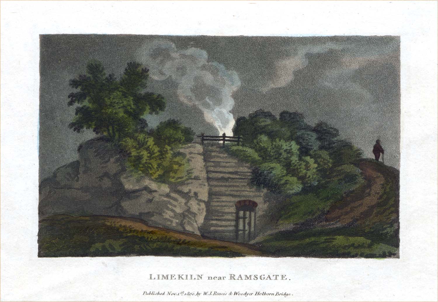 |
Figure 13. A lime kiln near Ramsgate, 1800 |
Early deeds for properties on the north side of Mill Lane tell us more about this part of Margate.28 The first, from 1681, records a conveyance from John Smith, a chirurgeon (doctor) of Margate, to John Prince of Margate, a famous local brewer of ale, of two acres of arable land ‘abutting to the Church way leading from Margate east to the way leading to the mill there from the street south, to the lands of John Smith north, to the lands of Matthew Smith and Nicholas Laming west’; ‘the way leading to the mill’ became Mill Lane and the ‘street’ became the High Street. The land then passed from John Prince to his son Thomas, and then to his son Richard, whose widow Mary sold it to Matthew Smith, a Margate butcher, in 1730, for £100.
It is not known when the Mill behind the church was built. The mill mentioned in Richard Norwood’s will of 1644 was probably Mill Lane Mill and an indenture of 1693 records the purchase of ‘Margate Mill’ by Roger Pannell.15,29 An analysis of the parish rate books by Arthur Rowe gives a list of the occupiers of the mill from 1716:30
1716-1717 Thomas Pannell
1717-1725 Roger Pannell
1724-1725 Mr Cowell (probably Benjamin Cowell the Elder)
1725-1730 John Webb
1730-1733 Mr Dunn
1733-1747 Mr Cramp
1747-1759 Thomas Hollam (Holland)
1759-1772 Thomas Doorn (Down) (pulled down)
In 1772 the mill owned at the time by Benjamin Cowell the elder, was removed by his son John Cowell to a new site where Thanet House was later built; the mill was eventually demolished in 1789.30 The reason for moving the mill was given in the Canterbury Journal:31
Last week a Windmill belonging to Mr Cowell, at Margate, was obliged to be moved a further distance from the town. The many new houseslately built near it obstructed the wind in such a manner that it could not work.
Amongst the lime kilns, herring-hangs, and the windmill at the upper end of the High Street were a number of malt houses. In 1766 an advertisement appeared for the sale of the property of the late William Jarvis, a Margate maltster:32
A freehold estate, lately the Property of Mr William Jarvis, Maltster, deceased, consisting of a large good Dwelling House containing three Parlours, three Chambers, two Shops two Kitchens, two Cellars, &c. together with a large Malt-house, that wets 20 Quarter per Week, also a Brewhouse, Stables, and other Out-houses, Yards, Gardens, &c. situated at the upper End of High-street, near the Church in Margate, very commodious, and capable of great Improvement.
A malthouse and a brewhouse at Church Hill, owned by Henry Petken and then by his son William Petken, brewers and maltsters, are also mentioned in mortgages of 1719 and 1737.33 These talk of ‘outhouses, malthouse, yard, garden etc. and two pieces of arable land about 8 acres, at or near St John’s Church hill, in tenure of Henry Petken’ and also of ‘copper tuns, barks, float, brewing vessels, great and small casks, utensils, implements of brewing, horses, carts, and dray.’ It is not known whether or not this was the property later owned by William Jarvis. Henry and William Petken were major figures in Margate, both, at one time, being Deputies of the town (Appendix I);34 they also had the original brewery on King’s Street that was later to become Cobb’s Brewery. An indenture of 1743 refers to a tenement owned by William Petken ‘commonly known by the name or sign of the Five Bells, late in occupation of Abraham Mummery, victualler, at yearly rent of £4 5s’.33 The Five Bells was a popular place used for entertaining by the Parish Overseers, first appearing in the Parish rate books in 1698.35 It seems likely that the Five Bells was the public house later to become the Six Bells, the public house that once at the top end of the High Street, facing the Church.
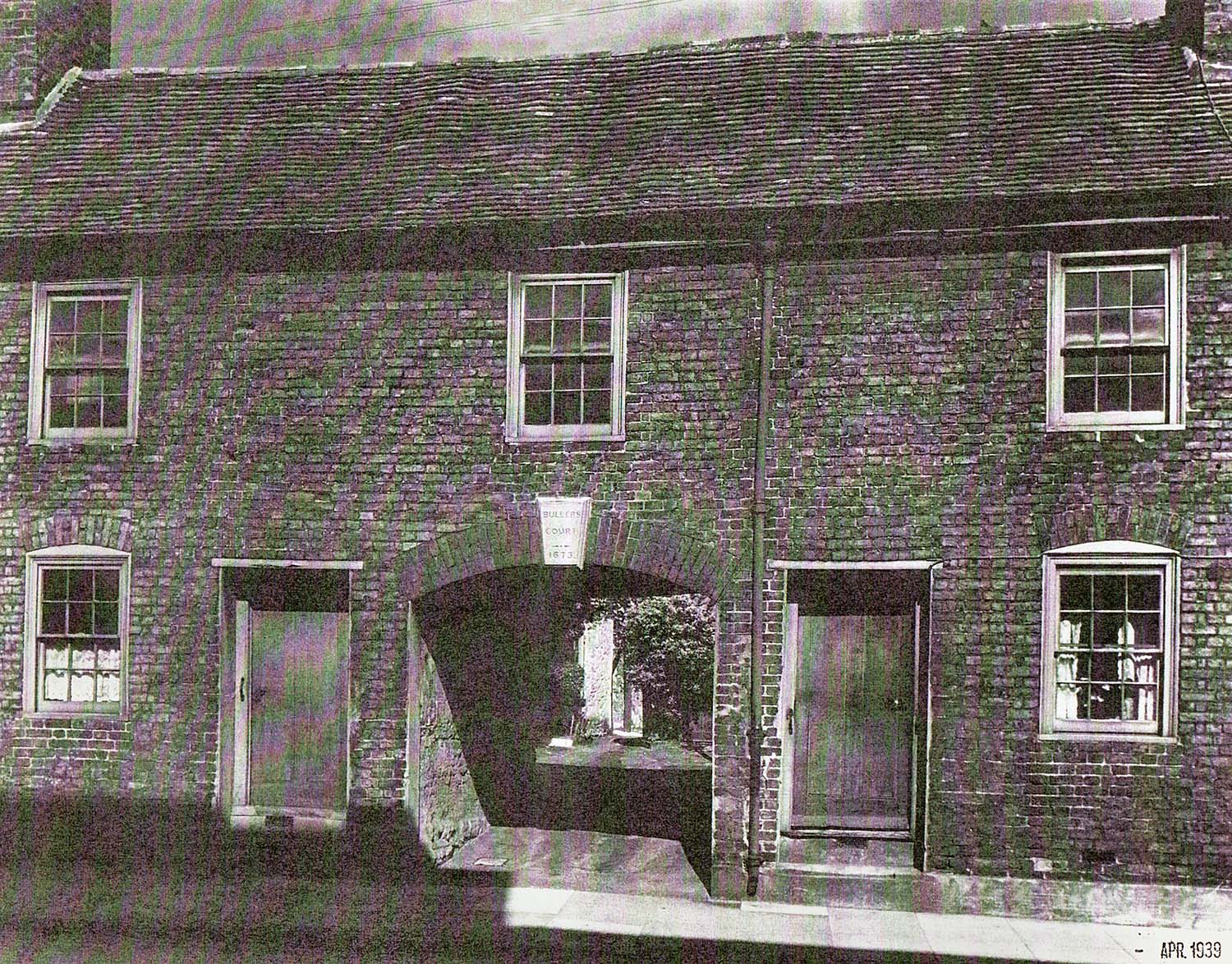 |
Figure 14. Buller’s Court in 1939. |
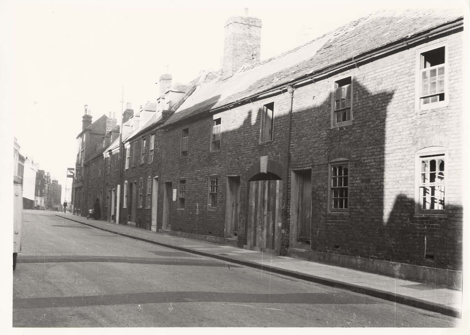 |
Figure 15. Old houses at the top of the High Street before demolition, looking towards the 'Hope and Anchor'. |
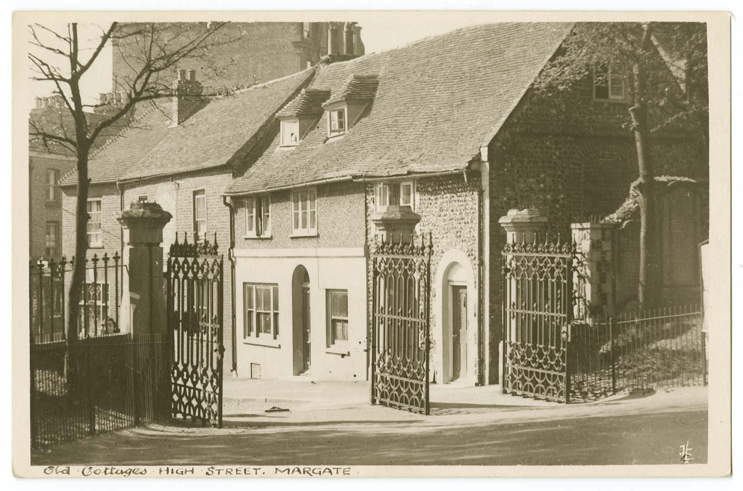 |
Figure 16. Old houses between the Six Bells and the west gate of the Church. |
Little is known about the houses at Church Hill; none of the old buildings now survive. An indenture of 1671 refers to ‘all that messuage in Church hill and commonly called Jumble House, now or later in occupation of Edward Cobb’,36 an intriguing reference given the fact that a group of old houses in this area were later referred to as ‘Jumble Joss Island’. Opposite the Six Bells was Buller’s court; photographs of Buller’s Court show that it bore a stone plaque above the archway leading into the Court, with the words ‘Bullers Court, 1673’ (Figure 14). John Lewis describes how, in 1673, Francis Buller gave to the Parish ‘several tenements, and half an acre of land, lying at Church-hill, the rents of which are to be laid out . . . in binding poor boys apprentices to some sea-faring employment’.1 Buller’s Court came to be used to house the poor, as described in Chapter 4. Further down the High Street, on the corner of High Street and Church Square, was another old courtyard, called Dixon’s Row on Edmunds map of 1821, but Dixon’s Place in a street directory of 1883.37 Rowe reports that this also bore an inscription, this time in the form of a brick insert ‘E.B. 1676’. Close by was Dixon’s Court; a sale of the estate of the late James Dixon in 1831 included a house at the entrance to Dixon’s Court, No. 69 High Street, containing nine ‘large airy rooms’.38 Edmunds 1821 map shows the One Bell public house in the northern corner of Dixon’s Court. An entry in the records of the Overseers of the Poor for 1733 shows a payment to ‘Mr [William] Simmons for half years rent for the house at the Signe of the Bell’ ; Rowe suggests that the overseers probably paid Simmons, a local brewer and maltster, for the use of one or more rooms in the inn as a parochial office.39 An indenture of 1777 for James Dixon speaks of ‘the shop formerly a smith’s forge and now a wheelwrights shop’ and an indenture of 1664 between John Parker and Josiah Simmons speaks of ‘a small piece of land with smiths forge’; it is not known whether the forge was in Dixon’s Row or in Dixon’s Court.38,40 The deeds of the old houses between the Six Bells and the west gates of the Church (Figures 15, 16) show that they date from before 1696.24
Land on the opposite, west, side of the High Street, between the modern Grosvenor Hill and Marine Gardens, was also sold off in the middle years of the seventeenth century. In 1650 Alexander Norwood sold 11 perches of land to John Hodges, yeoman; by 1781 Isaac Covell had built four messuages on this land, later referred to as Covells Row and found between Nos. 132 and 134 High Street.41 Three years earlier, in 1647, Alexander Norwood had sold 8 perches of land for £4 to John Spratling, ‘mariner of St John’s’; this was adjacent to the 11 perches of land sold by Norwood to John Hodges, land on which Hodges ‘soon after built a messuage, still standing [in 1680]’.42 These properties were to become No. 122 High Street; Nos. 122A and 124 were later additions built in the yard attached to No. 122.42 Further down we come to Nos. 106A and 106B High Street, in Prince of Wales’ Yard. These properties were built on some of the 40 perches of land sold by Alexander Norwood in 1647 to Henry Samways, a gentleman of the Parish of St John’s, for £5.43 The land already contained ‘two old thatched cottages and a draw well’. That the cottages were referred to as old in 1647 suggests that they could have dated back to the sixteenth century, and the selling price of £5 for the land and two cottages suggests that they must have been pretty ramshackle. On a further portion of Samways’ 40 perches of land were built what later became Nos. 98, 100 and 102 High Street.44
The picture we are left with is of a highway from the Church to the harbour that, before Norwood’s great sell off of land ran through open fields with just an occasional thatched cottage. Even after the selloff, plots of land were slow to be developed, and the many herring hangs and malt houses, not to mention the local lime kilns, scattered along its length well justified the judgment of future generations that it was ‘but a long dirty lane.’ It is not certain that much better can be said about the other King’s highway, the one that was to become King Street.
The second King’s highway ran from the Pier to Lucas Dane; to the north of the highway, running up to the Fort and the cliffs, was arable land. Lining the highway were a number of the more prestigious houses in Margate, together with malt houses and at least one brew house, later to develop into Cobb’s brewery. At the corner of the future King Street and Fort Road (previously Fountain Lane) was the Fountain Inn, later the site of Cobb’s Bank. The Fountain Inn extended almost a hundred feet along Fountain Lane, its odd shape reflecting its complex history.45 Part of the site, containing a house, shop and garden, belonged in 1688 to Jeremiah Fanting, described as a yeoman. The property passed to his granddaughter Mary, who was married to John Covell, who sold it to William Armstrong, described in his will as a Tavern Keeper. The neighbouring property, also a house, shop and garden, was sold by John Glover to Thomas Grinder in 1681, who then sold it to Ralph Constant in 1685; John Glover becomes important later in relation to the Mansion House. Ralph Constant’s wife Mary passed the property in her will to her three daughters, Mary Tomlin, Ann Laming and Elizabeth Pamflett. In turn they sold the property in 1731 to William Armstrong and it seems likely that he was responsible for the development of the Fountain Inn. In 1756 the Fountain was sold to George Friend and, in 1772, to Francis Cobb.46,47
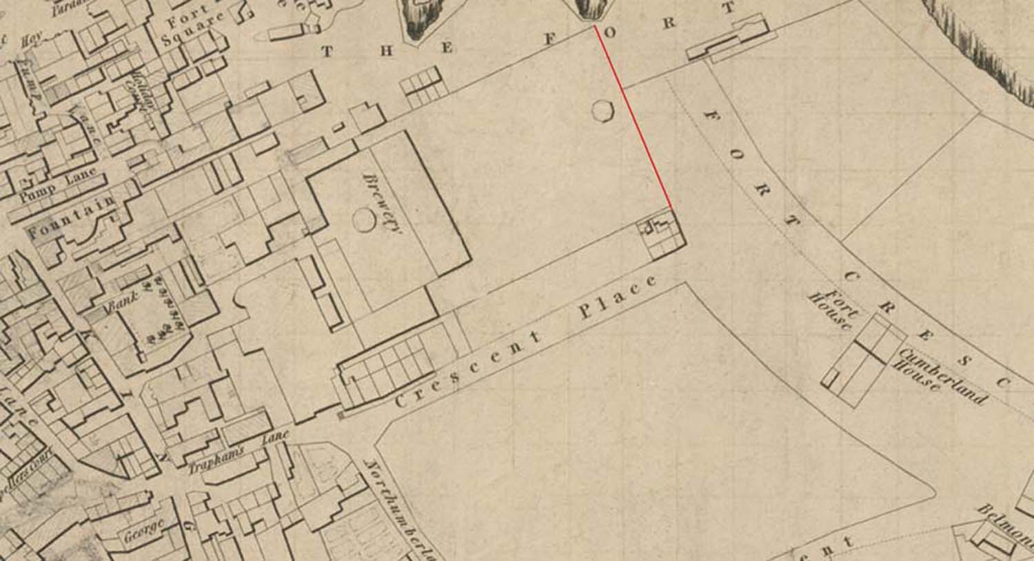 |
Figure 17. Cobb’s brewery site, from Edmunds map of 1821, showing its relationship to King Street and the Fort. The probable location of Tomlin’s wall separating the lands of William Goatham from the Fort is shown in red. |
Further along King Street was the site of what was to become Cobb’s Brewery (Figure 17). The site was large, extending from the highway up to the Fort. In November 1615 Richard Lee, a maltster of St John’s, acquired premises in Margate from William Parker, including a malthouse or brewhouse together with buildings and land, amounting to about 3 acres in all.48 His son, Daniel Lee, sold the property to Dame Mabel Finch, a widow of Canterbury, in 1663, at which time it consisted of land and a brewhouse, occupied by Richard May, a brewer, and a malthouse, occupied by Rowntree Cockaine.48,49 The property then seems to have returned to the Lee family as an indenture dated 1681 records the sale of the property by John Lee, a tailor of Canterbury, to William Petken, a brewer of Margate: it was described as ‘one malthouse and brew house, one millhouse, one stable, in or near a place commonly called or known by the name of Lucas Dane’. The location of the property was described as abutting ‘the King’s Highway towards the south, to the lands of Mary Wright widow towards the west, to the land of the heirs of James Trapham and to the Kings Highway towards the East, and to the Lands of John Jewell towards the North.’ An early name for Trinity Hill was Trapham’s Lane, (Figure 17) and, assuming that ‘the land of the heirs of James Trapham’ was located close to Trapham’s Lane, this locates the site of Petken’s brewery as the site of the later Cobb’s brewery. Ownership of the site becomes confused for a few years but evidently remained in the Petken family, passing from William Petken, on his death, to his wife Mary and to their two sons Henry and Thomas; on Henry’s death, the property moved to his son William Petken jun. and then, on his death, to his brother Henry Petken jun., who was now living in Dover. An indenture of July 1763 passed the property from Henry Petken jun. to George Rainer of Ramsgate and in August 1763 George Rainer sold it to Francis Cobb. The indenture of August 1763 described the property as:
all those 3 messuages, one counting house, two cellars, one washhouse, one brewhouse, and all the brewing vessels, copper implements and utensils of and belonging to the said Brewhouse, two large vaults, one stable, one malthouse, 2 dry lofts, one millhouse, two herring houses or storehouse, one summer house, two cowhouses, one coalhouse, one large Tiled lodge, three yards, 2 gardens, and a parcel of pasture land commonly called the Green which is walled in and contains ca 3 acres, and 2 small pieces of land with a carriage-way and gutter or watercourse heretofore part of a Great Backyard. All lying and together adjoining; some parts do abut bound or lye to or upon the Kings Highway or Street there leading from a certain place commonly called Lucas and otherwise Luke’s Dane to Margate pier towards the south and heretofore in the several tenancies or occupations of William Petken, John Pearse, Thomas Row jun. and Robert Brooke
 |
Figure 18. Sketch showing the location of properties on the Brewery Site, produced to settle an argument about rights of way, probably in 1796. Based on the original in the Kent Archives [Kent Archives U1453/T8 Foley House Deeds]. |
The original Brewhouse was on the north side of the highway, on the site of the garden behind the house later built by Francis Cobb on King Street.50 Close to the brewery site were three large houses, two of which can be identified with some certainty thanks to a sketch map produced, probably in 1796, to help settle an argument about access to the houses (Figure 18). The map shows the passageway giving access to the brewery site from the King’s Highway; the passageway was referred to in later street directories as Brewery Hill and is now Cobb Court. On the east side of the passageway were the house and lands of Captain Brooke (probably Captain Robert Brooke), previously belonging to Richard Lister. On the west side was land belonging to the Petkens, leading up to a house probably built by Benjamin Doncaster [or Donkester] in the 1680s; in 1682 Benjamin Doncaster, a mariner, bought 6 perches of land from William Petken, together with the use of a ‘carriageway leading from the Street or Kings highway south by the lands of Richard Lister up to the Gate or doors now late built upon some of the above bargained land’.46 In 1729 Benjamin Doncaster, now residing in Petersburg, sold the property to Richard Foley, and the house took the name of Foley House. In 1688 Captain Turner (probably Captain David Turner) purchased the land adjacent to the house as a garden (Figure 18) so that it is likely that Turner occupied the house at that time.46 In 1732 both Captain Robert Brookes and Captain David Turner were Pier Wardens (Appendix II).51 By about 1796 Foley House was in the occupation of Charles Boncey, a local builder.46 His advertisement for its sale in 1807 gives a description of the house:53
A large genteel Family House, called FOLEY HOUSE, situated near King-street, Margate; consists of two good parlours, two drawing rooms, hall, kitchen, counting-house, extensive cellars, large and airy bedrooms, makes fourteen beds; coach house, stable for six horses, a good flower and kitchen garden; large storehouses, pump with fresh water, and every requisite for a genteel family, or trade.
In 1811 Foley House was bought by Francis Cobb.46 The location of the third house off the King’s Highway , the Mansion House, is less certain and its interest, together with that of its builder, John Glover, is sufficient to warrant a separate section.
 |
Figure 19. The Tudor House as shown in Kidd’s 'Picturesque Companion to Margate, Ramsgate and Broadstairs and The Parts Adjacent', W. Kidd, London, 1831. |
Further along King Street we come to Lucas Dane proper which was, at this time, largely agricultural. Just beyond the future site of Cobb’s brewery, on the north side of the King’s highway, was a cart road leading to Northdown, shown on Edmunds map of 1821 as Trapham’s Lane and now known as Trinity Hill. A map of 1774 showing the land owned by Charles James Fox in this area shows a house with a malt house and garden on the east side of the junction of the cart road and the King’s highway, with land extending up to the cliffs; the house was later to be known as the Tudor House (Figure 19).54 The Tudor House has a complex history dating back to the sixteenth century or before.55 Abstracts of deeds date the house back to 1681 when it was sold to Thomas Grant, a mariner, by John Savage, another mariner; at the time the house and land was rented by John Laming, a member of a wealthy family of Margate ship-owners. John Savage was probably the son of William Savage who died in 1662;56 William Savage was a wealthy mercer, a mercer being a merchant, especially one involved in the export of wool and the import of luxurious fabrics such as velvet and silk.
The indenture of 1681 between John Savage and Thomas Grant suggests that by then the house was used as a farmhouse. The indenture describes a cart way 8 feet in breadth through the land to allow ‘horses, carts and carriages to pass up and down from the messuage lands . . . unto the King’s highway adjoining to the lands of the said Savage’, it being this cart way that eventually become Trapham’s Lane.56 The land and buildings were sold by Thomas Grant in 1687 to Stephen Higgins, a London victualler, who leased them in 1714 to Valentine Denne, a yeoman of Reculver; at this time the ‘tenement, garden, malthouse, barns, stables, Podwarehouse [the meaning of ‘Podwarehouse’ is now lost], storehouse, cellars, court yards, backsides, orchard, garden, well house, outhouses, edifices . . . and parcels of arable and pasture land’ occupied about 23 acres and were in the tenure of John Castle. A sale of the farm in 1741 refers to ‘the farmhouse wherein John Castle then or lately did dwell’, the first time that the house was explicitly referred to as farmhouse; a sale of the property in 1770 to Henry Lord Holland also refers to ‘all that farmhouse where John Castle did dwell’.56 A document of 1790 again refers to ‘all that messuage or farmhouse where John Castle [used to] dwell’ but then adds that it had been ‘converted into dwellings’.56 This is probably the state of the house shown in Kidd’s Guide of 1831 (Figure 19). Finally, in the early 1800s Fort Crescent, East Crescent Place, and West Crescent Place were built by Claude Benezet on the 20 acres of land originally belonging to the farmhouse.56
Another large farm in Lucas Dane was owned by James Taddy, a Margate mariner. In 1705 James Taddy married Susannah Laming, the daughter of Peter Sackett, a yeoman also of Margate, and Taddy, on his marriage, settled the farm on himself and his new wife.57 The farm was described as ‘all that Mansion House . . . with kitchens, barns, stables, gardens, orchard, backsides, court, yards, and appurtenances . . . also nine several pieces of arable land to the said messuage belonging, containing ca 40 acres . . . at or near a place called Wilds Dane or Lucas Dane and now in the occupation of John Cowell.’ In an indenture of 1733, the house was described as a farmhouse rather than as a Mansion House, and included a malthouse along with all the other buildings.57 The property remained in the Taddy family until 1795 when it was sold to Francis Cobb the younger.57 Unfortunately, the exact location of the farm is not known.
Behind the buildings facing the harbour was what is now referred to as the ‘Old Town’ (Figure 9). Unfortunately it is difficult to identify particular streets and buildings at this time as the requirement to name streets and number houses was only introduced in 1787 with the Margate Improvement Act. However, comparing Lewis’s drawing and Harris’s Map with modern maps of the town shows that as well as the buildings facing the harbour and those along what were to become High Street and King Street, houses had been built along another street running inland, later to be named Market Street. The site of the present Market Place was originally an open space called the Bowling Green. Lewis reported that ‘in 1631 I find a Market was kept [in Margate], of which a return was made to Dover every month, but this seems not to have continued long, nor does it appear by what authority it was kept at all’.1 The early market referred to by Lewis would have been just a series of market stalls for produce such as fruit, vegetables and meat, lining a street or an open space such as the Bowling Green, much like a modern street-market. The principal public and official buildings in many country towns came to be built around the market place, and a covered space would often be provided for the market stalls; often a hall or court room would be built above the market.58 This was the pattern of development at Margate, although the town had to wait until 1777 for its permanent market building, which was built on the site of the Bowling Green. A legal document of 1789 refers to buildings ‘near the place there formerly called the Pier Green since called the Bowling Green and then called Market Place’, 59 but this sequence of names seems likely to be wrong. An indenture of 1641 refers to a messuage ‘called the Queens Arms [abutting] a place called the Bowling Green’,60 and, since the present Queens Arms abuts the Market Place, this seems to confirm that the site occupied by the Market building was originally called the Bowling Green. Pier Green was the name used for a piece of land near the Pier and the papers in a legal case of 1755 describe how some time before the 1750s a storehouse had been built on a part of the Pier Green that had been used as a sawpit, and that the sawpit was then moved to the spot ‘where the Market now stands’.60 It is possible that the original name of Bowling Green was changed to Pier Green when the sawpit was moved to the Bowling Green site, but, if so, the name did not stick as deeds of 1705, 1729, 1765, 1768, and 1789 and a lease of 1765 all refer to the Bowling Green.62,63
Buildings around the Bowling Green were likely to have been mostly commercial premises. Rowe describes the deeds of an old butcher’s shop in the Market Place, Dale and Son, that was originally a herring-house, but was bought in 1707 by John Barnett, a butcher; Rowe established that the premises were certainly a butcher’s shop by 1752.24 An indenture of 1632 between John Bunson and Nicholas Woolman records the sale for £300 of the Old Kings Arms, ‘close to the green called the bowling green’, and, on the back of the indenture, someone has written ‘the Queen’s Armes’.64 The indenture of 1641 already referred to describes the Queen’s Arms as abutting on the Bowling Green, so that we can be fairly certain that the Old Kings Arms was an earlier name for the Queen’s Arms.
Leading into the Market Place was Puddle Dock, now called Love Lane, a lane lined by herring hangs and stables.24 At the corner of Love Lane and the Market Place was the Old Crown, mentioned in deeds of 1776.63 In neighbouring Lombard Street a brick building, still there, is decorated with small brick arches and pilasters and dates to the late 17th century, and must have been a prestigious house when it was built.65 The will of Edward Diggs in 1725 refers to five messuages ‘at or near Pier Green’ and a legal document of 1811 makes clear that these properties were in Lombard Street.59 In 1730 Jeremiah Jewell, of East London and John Jewell a Margate mariner sold 5 messuages on the south side of Lombard Street, ‘of yearly value 22 pounds ten shillings, now or late in the occupations of Thomas Slayton, Richard Laming, John Culmer, Thomas Burnell and Wm. Pain’, including a herring hang, to Stephen Swinford, another Margate mariner.66 Lombard Street was one of the earliest streets in Margate to bear a name, as indentures of 1738 and 1750 refer to ‘a certain street in Margate there called or known by the name of Lombard Street’.67
The Mansion House and John Glover
 |
Figure 20. Pump Lane, Fountain Lane and the suggested location for the Mansion House. The King Street area of Margate is shown from the Ordnance Survey Map for Margate of 1852, with the suggested location for the site of the Mansion House shown by the red rectangle. In Edmunds map of 1821 the block of houses between Pump Land and Fountain Lane is shown as containing just six houses. |
The location of the third of the large houses off King Street, the Mansion House, is uncertain because the house was demolished before the publication of the first detailed map of Margate, Edmund’s map of 1821. The most likely site for the house was on the east side of Fountain Lane at the point where Fountain Lane became a footway, as illustrated in Figure 20. The strongest evidence for this being the location comes from an indenture for the sale of the house in 1768.47 This describes the sale of:
all that messuage or Mansion House heretofore erected and built by John Glover, together with the outhouses, etc. securing and reserving the several rights of the respective owners of several messuages situate at or near a certain passage belonging to the said messuage or Mansion House, and then in the occupation of Anthony Walton, John Price, Richard Goadson, Joseph Griggs, Abraham Hedgecock, and Thos. White to the use of a way to go into and out of and from the back doors, of the six several messuages or tenements, by and through the aforesaid passage leading from the Street between the messuages there of John Gore, and a messuage there of Geo. Friend, known by the name of the Sign of the Fountain, up by the said messuage or Mansion House, and also from thence towards and up to the Fort Green there. . . . And also reserving to such persons who should be owners of the new-built messuages, standing in the aforesaid passage, in the occupations of Daniel Rose and Edw. Goatham, the right to the use of a way by and through the said passage (that is to say) a carriage and footway to and from the street, to and from the houses, and to and from the same houses to and from the Fort Green aforesaid only a footway.
The six messuages referred to here are the six houses shown in Edmunds map of 1821 making up the row of houses between Pump Lane and Fountain Lane. The passageway, later called Fountain Lane, ran from the King’s Highway or Street, later called King Street, along the side of the Fountain Inn. Edmunds map and the Ordnance Survey Map of 1852 shows that, just beyond the six messuages, Fountain Lane changed into a footway leading to the Fort. As described later, the Mansion House eventually passed into the ownership of Matthew and Stephen Mummery, who pulled it down and built a coach-house and stables on the site.47 All this suggests that the Mansion House was located on the east side of Fountain Lane at the point where it became a footway, as suggested in Figure 20.
The indenture of 1768 that has just been quoted continues:47
And also reserving to Francis Cobb, owner of a certain storehouse standing also in the said passage, to use of the passage, with liberty to turn any carriage in that part of the passage leading from the street to the entrance of the courtyard of the said Mansion House. And also reserving the use of the Pump standing near the said two new-built houses and the water thereof, and also the privilege of going in and out of the Great Gate standing in the same passage near to the said Pump, leading to a Lane called Pump Lane for the use and benefit of the said two new-built houses, the owners of the said two houses paying a proportionate part of the repairs of the said Pump and Gate.
The Pump, after which Pump Land was named, was located in a recess on the west side of Pump Lane opposite the Fountain Inn, where the old Ambulance Station building of 1896 was erected in what by then had become Fort Road.47
The story of the Mansion House starts in 1672 with the sale by John Crispe to John Glover, gentleman, for £150 of ‘all that messuage with the shop, outhouse, buildings and gardens, in Margate, towards the street there south, towards the Highway leading from the said street west and towards the messuage of Robert Brooke east’.48 The ‘street there south’ was the King’s Highway, later King Street. A second indenture, dated 1677, records a grant and demise [lease] by John Glover to Henry Yeates of ‘all that capital messuage then lately erected with all and every the outhouses buildings Court yards gardens and green spot of Grounds thereunto belonging, whereof part was then lately purchased by Jeffrey Tomlin gentleman.’ The indenture goes on to detail ‘one large capital messuage or tenement then lately erected and built by him and wherein the said John Glover then dwelt…’ and a ‘garden and orchard, together with the dove house, brewhouse and other outhouses’.48 The indenture suggests that John Glover over-extended himself financially in building the Mansion House and, indeed, in his will of 1681 he suggests that his wife Susannah should, if necessary, sell ‘the messuage and premises’ to pay his debts.47,68 During a court case of 1716 it was reported that about three years before the death of Susannah Glover, to whom the house had passed, Nicholas Constant ‘did hire from her half of the said house for which he gave the yearly rent of £8’.
 |
Figure 21 Oulton’s print of the Brewery 1820, showing the wall dividing the brewery land from Fort Green. From W. C. Oulton, 'Picture of Margate and its Vicinity', Baldwin, Cradock and Joy, London, 1820. |
The land referred to above as ‘lately purchased by Jeffrey Tomlin gentleman’ was probably at the north end of the site, close to the cliffs (see Figure 17). A document of 1697 records the gift by Jeffrey Tomlin, of St Peter’s, to William Goatham, brewer, in 1697 of ‘my chalk wall containing fourteen roods be there more or less with the ground whereon the wall standing . . . at or near a place there called the Fort Green’ separating the land of William Goatham from Fort Green.48 A rood, or rod, was a measure of length equal to about 16 feet,70 so that the length of this wall was about 224 feet. This matches the length of the wall shown on Edmunds map of 1821 separating the top end of the Brewery site from the Fort (Figure 17) and shown in Oulton’s print of 1820 of the Brewery (Figure 21).
John Glover died in 1685 and his wife Susannah died in 1713.71 In the court case of 1716 that followed Susannah Glover’s death, the Glover’s house, ‘commonly called the great house in Margate’ was described as ‘the largest and most capacious house in Margate’.69 The house had often been used by ‘persons of quality’ on their journeys from England to Holland or France.69 John Evelyn records in his diary on March 27 1672 that on a visit to Kent he stayed at Margate and ‘was handsomely entertained and lay at my deputy’s Captain Glover’.72 In a letter of November 1677 to Sir Joseph Williamson, John Glover reported that ‘last night, the wind being S., the Prince and Princess of Orange went on board Sir John Holmes and stood off to sea, but, the wind coming N.E. in the night, they came back again into this road, and about 11 this morning came ashore to my house, where at present they are in very good health’.73 In her evidence to the court case of 1716 Martha Harman, Susannah Glover’s servant, reported that ‘his late Majesty King William, his Grace the Duke of Marlborough, his Grace the Duke Shrewsbury and diverse other persons of quality and distinction in journey or passage from England to Holland or France . . . did frequently take up the said house and sometimes lodge there at other times . . . for which they used to make presents or other gratifications to the said Susannah Glover’.69 Following Susannah Glover’s death in 1713 the house stood empty while the arguments over her will were fought through the courts. Martha Harman reported that after Susannah’s death, although people of quality had been at Margate, ‘they did not stay in the House but went to the house of Mr Jewell and lodged there’.69 Confusingly, one of the London papers, Applebee's Original Weekly Journal, reported in November 1720 that: ‘Yesterday Morning, between One and Two, his Majesty landed at Margate in Kent, and lay at the House of Mrs Glover in that Town, and came to St. James’s last Night’.74 Since this was seven years after Susannah Glover’s death either her old house was again being used by ‘persons of quality’ or the paper had got it wrong.
Even before Susannah Glover’s death the house ‘was very much out of repair’ and it was reported that ‘the stable belonging to the said great house was blown down several years before the death of the said Susannah Glover’.69 Vincent Barber, a ‘house carpenter’ reported that the house ‘was unfit for any Gentleman’s use without repairing’ and that ‘the said house standing out of the way of trade and business’ was ‘only fit for a Gentleman’s use.’ Edward Constant, the Margate postmaster in 1716, reported that at the time of Susannah Glover’s death ‘the said great house, outhouses and garden were in tolerable repair sufficient for any common tradesman but not for a Gentleman.’
Following the end of the court case in 1717 the house was advertised for sale in the London Gazette:75
A good brick messuage, four rooms on a floor, situate in Margate in the Isle of Thanet in the County of Kent, with good gardens, brewhouse, stables, and other conveniences, late the estate of John Glover, Gent. deceased, is to be sold by decree of the High Court of Chancery, before John Bennett, Esq, one of the Masters of the said Court. Inquire for a particular at the said Master’s House, at the upper end of Chancery lane.
The house was finally purchased in 1721 from James Glover, son and heir of John Glover, by John Wheatley of Margate, acting on behalf of Stephen Baker, a gentleman and mariner of Margate.47 Stephen Baker died in 1751, and, in his will proved ‘on oath of Elizabeth Baker spinster’, he left money and ‘my fishing boat’ to John Baker, and money to his son Stephen and to his daughter Elizabeth.76 Although there was no specific mention of the Mansion House in his will, it was clearly passed on to his daughter as her will of 1764 declares:77
First I give and devise all that my messuage or Mansion House with all and singular the outhouses buildings yards gardens land hereditaments . . . situate in Margate . . . now in my own occupation and also all those two messuages or tenements and all that Brewhouse of building with the outhouses buildings ground . . . together adjoining near to my said Messuage or Mansion House and now or late in the several occupations of Daniel Rose, Edward Goatham and George Friend . . . and also all that Messuage or Tenement with the outhouses buildings ground . . . at or near a place now called Puddle Dock and now or late in the occupation of John Palmer together with all other my messuages lands tenements . . . real estate . . . unto Richard Ward of Woolwich in the said county of Kent, Shipwright and John Baker of the parish of St John.
Richard Ward and John Baker were to sell the property, including ‘my said Mansion House’ and to use the money for a variety of bequests specified in the will.
The house was duly advertised for sale in a London paper in 1766:78
To be sold to the highest Bidder, on Tuesday the 6th day of May . . . at the New Inn
The several messuages and tenements after-mentioned, situate and together being in the said town of Margate in several lots, viz.
Lot 1. A large Mansion-house, with four rooms on a floor, late in the occupation of Mrs Elizabeth Baker, deceased, standing upon a rising ground, so as to command from some of the upper rooms a prospect of the sea and land: the size of each room as follows, viz,
|
Length |
Breadth |
Height |
|||
|
Feet |
Ins. |
Feet |
Ins. |
Feet |
Ins. |
The Ground Floor |
|
|
|
|
|
|
One large kitchen |
20 |
6 |
20 |
1 |
8 |
0 |
One scullery with pump |
21 |
1 |
9 |
6 |
||
One cellar |
17 |
6 |
14 |
6 |
||
One cellar with pantry |
11 |
3 |
7 |
6 |
||
A place for coals |
11 |
3 |
7 |
6 |
||
The First Floor |
|
|
|
|
|
|
One large parlour with two closets |
21 |
4 |
16 |
8 |
9 |
8 |
One parlour with ditto |
14 |
7 |
12 |
0 |
||
One servants hall |
17 |
10 |
13 |
0 |
||
One back parlour |
17 |
10 |
11 |
8 |
||
A fine open stair-case with two others close |
|
|
|
|
|
|
The passage leading from the fore door |
|
|
6 |
8 |
|
|
The Second Floor |
|
|
|
|
|
|
One large dining-room hung with painted cloth |
21 |
9 |
21 |
6 |
10 |
10 |
One chamber |
21 |
6 |
15 |
9 |
||
One back chamber with closet |
17 |
8 |
12 |
0 |
||
One back chamber with ditto |
18 |
3 |
17 |
8 |
||
The Third Floor |
|
|
|
|
|
|
One large laundry |
25 |
0 |
16 |
0 |
8 |
3 |
One chamber |
15 |
8 |
14 |
6 |
||
One chamber |
18 |
0 |
14 |
7 |
||
One chamber |
16 |
0 |
14 |
6 |
||
Two small store rooms, each |
14 |
6 |
7 |
0 |
||
The garden before the house |
50 |
6 |
41 |
6 |
|
|
The back yard |
42 |
0 |
12 |
0 |
|
|
The garden behind the house |
97 |
6 |
42 |
0 |
|
|
N.B. The gardens and yard are walled in. |
|
|
|
|
|
|
Lot 2. One new built messuage, in the occupation of Mr Daniel Rose.
Lot 3. One new built messuage, in the occupation of Mr Edward Goatham.
Lot 4. One store-house with a vault thereunder, in the occupation of Mr George Friend, or his under tenant, the size thereof being 54 feet 9 inches by 20 feet.
N.B. The premises are all freehold.
Enquire in the mean time of Mr Richard Ward, at Woolwich, in the county of Kent; Mr John Baker, at North Down, near Margate; or Mr Daniel Marsh, attorney at law, in Margate.
The property did not sell and in 1767 Francis Cobb took the opportunity to purchase just the ‘brewhouse and storehouse and vaults’, but not the house.48 The Indenture of sale, as usual, described the location of the brewhouse property and also clarified the rights of access to it:
abuting and bounding to a building or ground of Stephen Sackett towards the East, to a building or grounds of George Friend towards the south, to a passage belonging to and leading from the Street up to the Mansion house late the said Elizabeth Baker’s and from thence to the Fort Green there towards the West, and to a messuage or tenement also late the said Elizabeth Baker’s now in the occupation of Edward Goatham towards the North, or howsoever otherwise the said premises do or doth abut bound or lye late in the tenure or occupation of George Friend or his assigns or under-tenants and now or late in the tenure or occupation of the said Francis Cobb his assigns or under-tenants which said Brewhouse, Storehouse or building and premises hereby granted and released being part and parcel of the said messuages, lands, tenements and hereditaments before mentioned to be devised by the said Elizabeth Baker to be sold as aforesaid and were heretofore the estate and inheritance of the said Stephen Baker deceased and are part of the estate purchased by John Wheatley of James Glover and others by indentures of lease and release in trust for the said Stephen Baker – and also the free use liberty privilege and benefit from time to time and at all times hereafter of a way in over and through the passage aforesaid belonging to the said Mansion house from the street to and from the said Brewhouse, Storehouse or building and premises for the said Francis Cobb, his heirs and assigns and his and their tenants servants and workmen to pass and repass in over and through the said way with horses, cattle, carts and other carriages . . . and liberty at all times to turn any carriage in that part of the said passage leading from the street to the entrance of the Court yard of the said Mansion house. And also the free use . . . of a footway from the said Brewhouse Storehouse or buildings and premises in over and through the said passage up by the said Mansion House to and from the Fort Green aforesaid for the said Frances Cobb.
The Mansion House itself was advertised again in 1768, this time in the Kentish Gazette, and with less detail:79
TO BE SOLD; By Public AUCTION, to the Highest-Bidder, at the Mansion-house after mentioned, on Monday the Twenty-second Day of August Inst. between the Hours of Four and Five o’clock in the Afternoon,
The said MANSION-HOUSE (being Freehold) having four Rooms on a Floor, Closets, and other Conveniences, Two Gardens walled in, viz. a fore Garden and a back Garden, and all other Appurtenances to the same belonging, situate in Margate, upon a rising Ground, so as to Command, from some of the upper Rooms, a prospect of the Sea and Land, late in the Occupation of Mrs Elizabeth Baker, deceased.
And in two separate Lots, Two New-built MESSUAGES or TENEMENTS (being likewise Freehold) situate also in Margate, near to the said Mansion-house; now in the several Occupations of Daniel Rose and Edward Goatham. For further Particulars enquire of Mr John Baker, at North Down, near Margate, or Mr Daniel Marsh, Attorney, at Margate.
The house was bought at the auction by Thomas Smith for £400, on behalf of Holles Henry Bull of Strand in the Green, Chiswick.47 It remained in the ownership of the Bull family until 1792 but toward the end was occupied by Francis Sackett who ran a boarding house there. Sackett advertised the attractions of the ‘Royal Mansion’ in 1788:80
Royal Mansion,
At Margate in Kent, near the Play-house
Francis Sackett begs leave respectfully to inform the Noblemen, Ladies, and Gentlemen, that he keeps a good table, and other accommodation at the following terms, viz;
|
£ |
s |
d |
For the first floor per week |
1 |
8 |
0 |
Second floor ditto |
1 |
6 |
0 |
For boarding, without Lodging |
1 |
1 |
0 |
For boarding, without Lodging |
|
4 |
0 |
The reference to ‘near the Play-house’ refers to the location of the original Margate playhouse, at the Fountain Inn.81
Following Bull’s death the house was advertised for sale in The Times, in 1791, by which time it was known as Sacket’s Boarding House;82
For sale at Bensons Hotel . . . Large freehold mansion house with four rooms on a floor, known by the name of Sacket’s Boarding House; situated near the Fort, standing on a rising ground, so has a command from some of the rooms of a prospect of the sea and land, the busy picture of the London Commerce passing in Review, capable of great improvements. A garden behind the house 97 feet 6 inches by 42 feet, with a door that opens into the Fort. Back yard 42 feet by 12. The approach from the Street is a Coach road to the House, inclosed with iron gates. A flower garden in front, walled round, 50 feet 6 inches by 41 feet 6, with a flight of stone steps. Coach house with stabling for two horses, and loft over.
The above premises are fit for the reception of a genteel family.
The corresponding advertisement in the Kentish Chronicle of June 14 1791 is the same as that in The Times , but incudes full room dimensions, exactly matching those in the advertisement of 1766 quoted above.83
The house was bought in 1792 by John Mitchener, of the New Inn, and John Drayton Sawkins.47 It is possible that the House was then occupied by a school teacher, Mrs Peacock, who advertised in 1796 that ‘Mrs and Miss Peacocks – Mansion House – school recommences on 25th’.84 However, in 1803 it was sold by Mitchener and Sawkins to Matthias Mummery, a Margate coachmaster, and Stephen Mummery, a Margate farmer.47 An indenture of 1809 reported that ‘Matthew and Stephen Mummery had pulled down the Mansion House, and on the site and grounds thereof had built . . . coach-houses, stables, and buildings’ referred to as being ‘in or near Pump lane and Fountain Lane’, and that they had used the property as a security for a loan of £2500 from Francis Cobb and Francis William Cobb; in 1816 the Mummerys were declared bankrupt on a petition of the Cobbs.47
A little is known about John Glover, who built the Mansion House and was a man of some standing in Margate. In the parish church was a memorial to ‘John Glover, Gentleman, who died at London in 1685, aged 56 years, born in 1629’; an inscription underneath recorded the death of his wife, ‘Mrs Susanna Glover, his wife, Obiciit in 1713, aged 75 years’.71 At the time of his death he left an estate worth some £2000, with shares in a number of ‘good ships and vessels’.69 In 1656 John Glover had been made master of one of Oliver Cromwell’s ships:85
To Commissioners of Admiralty and Navy. Our will and please is that you forthwith make and direct your warrant to John Glover of our Isle of Thenet in our Countie of Kent gent authorizing him to bee Master and Commander of our shallop called The Welcome of our Port of Margate in the said Isle, for our special and ymediate service at sea. Given at Whitehall the Nineteenth day of February 1656.
This was a position of no little importance because of the extensive naval activity off the coast of Margate at the time, resulting from the three wars fought with the Dutch during the years 1652 to 1674 (Chapter 6). At one time he was also postmaster at Margate, but a petition to the Privy Council in 1658 shows that, about this time, he was in some trouble:86
April 22 1658. Petition of John Cockaine, John Hill, and Hen. Giles, to Privy Council.
Being ordered to appear before you, to give evidence on a charge against John Glover, officer of Margate, Kent, we have attended 12 days. Being very poor, and having large families, we beg speedy hearing or dismissal till required, and an order that Rich. Bartlet, surveyor of Customs at Gravesend, may then appear.
The nature of the charge is unknown, but a letter of 1660 from the Council of State to the Commissioners of Customs describes John Glover as ‘late postmaster’ at Margate and suggests that the the Commissioners of Customs might like to think about dismissing him from his job with them as searcher and waiter at Margate:87
January 28, 1660. Council of State to the Commissioners of Customs. Being informed that Jno. Glover, customer and searcher at Margate, and late postmaster there, is very intimate and holds correspondence with disaffected persons, — whereby, if he be continued in that employment, danger may ensue, — we have removed him from the office of postmaster there, and appointed Nich. Hooke in his stead. We recommend you to remove Glover from being customer and searcher of that port, and to put Hooke into the employment, if you hold him qualified.
There is no record of whether or not Glover was in fact dismissed from his post with the Customs at Margate, but there is a record in 1672 of his appointment as commander of a Customs smack at Margate:88
The Treasury Lords to the Customs Commissioners to employ Capt. Glover as commander of a Customs smack to be settled about Margets and Ramsgate: with an establishment of £306 per an. for himself, one mate, 6 men and a boy for said smack.
This appointment was short lived as in 1675 it was decided to remove the smack at Margate and instead for the ‘smack at Quinborough [Queenborough] to have the inspection of the Isle of Thanet insead of . . . Mr Glover’; Glover was then dismissed ‘as an unnecessary officer’.89 >
Glover’s period as commander of a Customs smack coincided with the third of the Anglo-Dutch wars, from 1672 to 1674 (Chapter 6). During this period Sir Joseph Williamson, Under Secretary to the Secretary of State, headed the government’s intelligence network of informants. He had correspondents in almost all the ports along the east and south coasts of England, many of whom were customs officers, and one of them was Glover (Appendix III).91,92 Williamson’s informants were not paid for their work but often received a copy of his manuscript newsletter, an important source of news at a time when the only licensed news sheet, the London Gazette, carried no domestic news worth reading. Informants were instructed to write to Williamson by every post, as acknowledged in the first of the letters sent by Glover to Williamson on May 10 1672:93
May 10, 1672. Margate.
John Glover to Williamson. According to the directions of yours of the 8th I will give you an account daily. Just now came about the Foreland two Holland men-of-war, and a great flyboat, which I conceive is a fireship. They all lie loose with their sails baled up, and have stopped two billanders that were coming in upon the Foreland. The whole fleet are at the back of the Goodwin. If the ships you spoke of come over the flats, it will be very dangerous
if these Dutch ships continue on the Foreland; but if it be resolved they shall come, I will have lights kept on the two buoys, that they may come through by night as well as by day. I am just going to the Foreland.
He then wrote again the same day:
May 10, 1672, 2 pm. Margate.
John Glover to Williamson. Since my last by Mr Langley's express [the postmaster at Margate] I have been at the North Foreland and on the lighthouse, which is the best prospect we have, and while there another ship came in upon the Foreland, and spoke to the three I mentioned in my last, and after they had lain by about half an hour they made all sail, and stood off the Foreland again, carrying with them the billanders they stopped, and, I presume, they will go off to their grand fleet, which lies off the flats of the Foreland, and at the back of the Goodwin. These are all the ships that were in sight, only one great ship was between the Northsand head and the Foreland, but she stood off when she saw the others stand off too. It is very hazy, with wind N.N.E., so that we cannot see far to sea, but about sunrise this morning the whole Holland fleet was seen at the back of the Goodwin, and about 30 nearer in upon the Foreland than the rest. If the ships yet in the river are ready to come down, my boat shall ply off the Foreland and inform me of all ships there, and I will contrive, by boats placed from the Redsand to the two buoys of the Narrow with lights in them, and by lights at the two buoys, that the ships shall come down as well in the night as in the day, and then those ready may be at the Foreland before daylight, and if any of the Holland fleet be there, it will not be above four or eight sail, for they never come in with more. If you will tell his Majesty he will doubtless understand the management of the affair, and if it be concluded pray send me orders what I shall do, and I will consult the commanders about it, and doubt not to bring them down safe. I will send you an account every night by express of what happens here in the day, so pray write to the postmasters to forward them. I guess the biggest ship here not to have above 50 guns, and the rest 20 or 30 apiece.
In his next letter, of May 11, John Glover explained that he had to send his letter via Sandwich, as mail from Margate was only sent out on Tuesdays and Fridays.93Despite these problems Glover managed to keep up a regular stream of letters to Williamson, although most contained little of interest.
In November 1672 John Glover wrote to Williamson asking for a job, either as postmaster again, as Richard Langley had just died, or as a customs officer:94 ‘Mr Langley is dead, and the post place here not yet settled, but let me receive your commands, and I will serve you what I am able, but the Commissioners of the Customs have deprived me of my employment in the smack, which I hope you will be a means to restore me to, when you hear my case’. In 1675 he asked for a reward of £52 for having seized a load of wool and a small boat:95 ‘John Glover of Margate. Petition for a gift of about £52, the King’s moiety of a seizure of wool, now in the petitioner’s hands, and of a small boat forfeited for importing fish. Was often employed during the late Dutch war to go on board his Royal Highness with letters and messages as he and Sir J. Williamson can testify, his charges being above £60.’
With the end of the third Dutch war in 1674 the regular correspondence between Glover and Williamson came to an end, but there is one final letter of interest, concerning religious dissenters at Margate, whose meeting houses were referred to as conventicles:96
February 12 1675. John Glover to Williamson
The fanatic party are building a conventicle house here where we never had any before, and I know not why they go about it now unless it be in spite of the proclamation against them. They make great haste to get it up, and I tell them it may be it will be pulled down as fast ere long.
This was probably a reference to the Baptists. There was a Baptist church in Dover in 1654, and the Baptists met in the Isle of Thanet in a chalk pit at St Peters; the first Baptist chapel was built in Thanet in 1690 by Stephen Shallows, at a site known by his name.97,98
Inns and Innkeepers
Margate in the seventeenth and eighteenth centuries enjoyed some renown as a port of embarkation and disembarkation for the Low Countries (Chapter 2). Travellers using the harbour would sometimes need overnight accommodation and somewhere to eat and drink, facilities provided by the local inns. Inns also served as staging-points for carriers and coaches and, in the absence of other public buildings, as places where traders, farmers and ship’s masters could meet to discuss business; they also provided rooms where public events such as meetings and auctions could be held. In fact, in the years before the middle of the eighteenth century, Margate seems to have been rather poorly served with inns. A list of ‘tavernes in tenne shires about London’ published in 1636 included just two in Margate, those of ‘Averie Ienkinson and Henry [..]ulmer’.99 The second of these is probably Henry Culmer, Culmer being a common Margate name at the time; a Henry Culmer was buried at St John’s in 1661. A national survey of the accommodation available at inns and alehouses in England in 1686 found that Margate had just 27 guest beds and stabling for just 40 horses, compared for example, to 236 guest beds and stabling for 467 horses in Canterbury, and 132 guest beds and stabling for 189 horses in Dover; Ramsgate had 17 available guest beds and stabling for 19 horses.100 These numbers had, however, increased considerably by the time of a second survey in 1756, the report of which provides more information about how the survey was carried out.101 In 1693 the country had been divided into 39 areas for Excise purposes, the areas being called Collections, loosely based on County boundaries. Each Collection, under the control of a Collector, was divided into a number of districts under the control of Supervisors. Districts were usually centered in local towns, and were referred to as Divisions; the countryside outside a town was called an Out-Ride. Margate was in the Sandwich Collection, and the town of Margate made up the Margate Division, with the surrounding countryside, probably corresponding to the rest of the parish of St John’s, making up the Margate Out-Ride. In 1756 the Margate Division contained 16 inns and public houses, with 46 beds and stabling for 29 horses, and the Margate Out-Ride contained 12 inns and public houses, with 19 beds and stabling for 33 horses, giving a total of 28 inns and public houses, 65 beds, and stabling for 62 horses.101 This is somewhat more than the provision at Ramsgate, which had 21 inns and public houses, 34 beds and stabling for 56 horses, but considerable less than the 69 inns and public houses with 182 beds and stabling for 193 horses available at Dover. These numbers emphasize that the number of travellers passing through Margate at the time was still very small compared to the number passing through Canterbury or Dover, and that Margates few inns were rather small.
The larger of the inns were likely to have been located close to the harbour, on what was to become the Parade and Bankside. Edmund’s map of 1821 and the Ordnance Survey map of Margate of 1852 show six inns there, starting at the west end with the York Hotel at the junction of Duke Street with the Parade and, next to it, the White Hart Hotel at the junction of the Parade with Bridge Street. Further to the east were the Hoy Inn, at the junction of Bankside with Pump Lane, and the Ship Inn, the Dukes Head Hotel, and the Pier Hotel, originally the Foy Boat, opposite the Pier. The most important of these inns for the history of Margate was the York Hotel, originally called the Black Horse Inn, and renamed the New Inn from 1761 and the York Hotel from 1793. It was here that Thomas Barber erected the first salt-water bath in Margate in 1736 and where, in 1753, his widow built the first assembly room in Margate.102,103 The early history of the Black Horse is unknown. We know more about the early history of the White Hart, although much of that is confusing. The first deed for the White Hart identified by Arthur Rowe was dated 1701: ‘John Savage, victualler, of the White Hart, leaves to Mary Savage, his wife, the White Hart, and all stables, buildings, and outhouses, and gardens. Also all those two messuages adjoining, in the occupation of John Turner and Arthur Geerson’.24 In 1711 Mary Savage married Edward Constant, a mariner, both of whom died in 1729.24 An advertisement in 1729 in the Kentish Post announced that ‘Valentine Jewell, junior, who married Mr Abraham Hudson’s Daughter of Deal, having taken the sign of the White-Hart Inn in Margate, Mr Constant and his wife being deceased; this is to give notice, that all Gentlemen and others will there find good entertainment; and may be furnished with good Horses, at reasonable Rates’.104
A clue to the earlier history of the White Hart is provided by references to an inn known as the Posthouse. A post-house or posting-house was a house or inn where stage coaches stopped, horses were fed and watered, teams changed, and post-chaises could be hired for short journeys off the main coach-routes. Although posthouses were not necessarily connected to the postal service, local postmasters were often innkeepers who took the position of postmaster to bring custom to their houses.105 The advertisement referred to above shows that Valentine Jewell purchased the White Hart after the death of the previous owners, Edward Constant and his wife. However, witness statements in the legal case of 1716 concerning the will of John Glover were taken ‘at the dwelling house of Edward Constant commonly called by the name of the Posthouse in the village of Margate’.69 The obvious conclusion is that the White Hart and the Posthouse were one and the same. The witness statements also describe Edward Constant, a witness in the case, as ‘postmaster’.
There are several other early references to the Margate Posthouse. One is in A new journey to France, a book published by J. Baker in 1715, describing incidents on his journey:106
Margate is a small village in the Isle of Thanet, just on this side of the point call’d the North Foreland . . . we arrived safe at Margate . . . I lay there at the Post-house . . . and next day I set out in a wherry for Gravesend
A more intriguing reference occurs in an account of the role of Captain William Ricards in foiling a plot against the life of William III in 1695. Ricards at the time was living in London:107
[and] he became intimate with one Bourne, who in conversation . . . confessed that he had come to the knowledge of a traitorous conspiracy against the King. After which, Mr Ricards never left him till he went with him to Sir William Trumbal, one of his Majesty’s Principal Secretaries of State, about the 20th of September, 1695, at what time his Majesty was expected to return to England [from Holland] . . . Bourne gave sufficient information to satisfy Mr Secretary there was a secret enterprise resolved upon; to execute which several persons lay concealed at Margate, where it was expected his Majesty would land [and] that these men were provided with firearms, and had a vessel for their service, which lay off of Margate . . . The Secretary of State, and Lords of the Council, thought it prudent to look farther into the matter, and see whether any such persons could be found at that place. To this end, they proposed to Capt. Ricards to go himself thither, having understood by him that he was a native of that place, and very well acquainted with it; they offered him whatever assistance and support he desired. Their Lordships had no difficulty to prevail with a gentleman so well affected to King William, to undertake that service; and the Earl of Romney, Lord Warden of the Cinque Ports, signed the following warrant.
To all whom these Presents may concern.
Know ye, that the Bearer hereof, Capt. William Ricards, by command from me, is commissioned hereby to seize and apprehend several dangerous persons, of which you shall receive notice by him. I therefore hereby require and command all officers both military and civil, to be aiding and assisting to the said Capt. William Ricards, in effecting the same. Given under my hand and seal this 25th day of September, 1695.
ROMNEY
Capt. Ricards took two yachts, and a company of soldiers from the tower [of London], and without communicating his departure to any one person whatsoever, made down to Margate; pretending to spend a few days with his friends and acquaintance there, whom he had not seen in many year: and that none of them might take it ill in particular, that he did not lodge at his house, he took lodgings at Paul Hart’s, the Posthouse, yet the most suspected place in the town for the conspirators to be conceal’d in. Major Gregory, Tower-Armourer, was the only man who came ashore with him, and tho’ he made as diligent search as could be done, without giving the alarm to those that were concealed there, he at first made no discovery, those persons keeping close all day. The wind was contrary, and kept the King back a fortnight, and in that length of time, Capt. Ricards found out that there were persons concealed in the house, with some circumstances that were very suspicious. Five lodg’d in one room, where was good store of fire-arms, and that room very convenient for any sudden attempt upon landing; He often heard them drink mysterious healths in their midnight revellings, ‘twas plain by their discourse that there were others concerned, by whom they expected to be joined, as soon as they were ready for it; which fully convinced Capt. Ricards that he could not use too many precautions, to prevent their executing their hellish design.
The wind coming fair for his Majesty, he ordered the officers of the yachts ashore, and invited several of his friends in the town, which he could trust, to an entertainment, under pretence of paying his foy [a farewell feast or drink] upon his return to London the next day: and after he had entertained them till near midnight, he fasten’d the door, and made known to the company the business he came for, and what he had done in it; that he had discovered several suspicious fellows, who were concealed in that House, and he then shewed the necessity of securing their persons before the King landed. He called in Paul Hart the inn-keeper, and clapping a pistol to his breast, threatened immediately to shoot him, if he did not discover who were the persons concealed in such a room in his inn, and what was their intent. Paul Hart presently owned their being there, and that they had been thus shut up in a room for some time, but he knew not their Intent, nor anything more of them, than that they ordered him to keep their being there a secret; and that as soon as the fleet which was to bring over the King appeared in sight, he was to knock at their chamber-door, and say Twynam is come. Capt. Ricards obliged Hart to go with him and his friends directly to the room these fellows were in, to knock at the door, and cry Twynam is come; upon which, it was immediately opened by an Irishman, who seemed to be the head of them; he had a pistol in his hand, which Capt. Ricards laid hold on, and obliged him to drop it; and the company breaking in at the same time, secured the rest in their beds. He found a great many fire-arms, as Bourne had informed him, which were all loaden; and lay on the table. The King landed in a few hours after, and Capt. Ricards brought away the five ruffians to London, where they were committed to Newgate, and having lain there some weeks, they were let go; Bourne’s evidence being single, and not sufficient to convict them of treason.
Paul Hart, as well as being the innkeeper of the Posthouse, was also the Margate postmaster but was dismissed in 1697 for ‘assisting in the running a parcel of lace’.108
The White Hart remained in the hands of Valentine Jewell until at least February 1747. An advertisement for an auction of smuggled drinks held in 1737 in the White Hart announced:109
To be sold to the highest and best bidder, by publick sale, On Tuesday the 12th of July, 1737, by one o’clock in the afternoon, At the House of Valentine Jewell, call’d or known by the name of the White Hart in Margate in the Isle of Thanet,
70 Hogsheads of French white wines in good condition
16 ditto, but indifferent
1 ditto and half French claret in good condition
670 Gallons of good old French brandy,
In several lots, clear of all duties.
Again, ten years later, in February 1747, the auction of a ship, the Success, was advertised ‘at Mr Valentine Jewell’s at the White Hart in Margate’.110
However, later in 1747 the situation becomes confused. An advertisement of May 1747 reported that the master of the Posthouse was Michael Trapp:111
WHEREAS Bathing in the SALT-WATER, hath been found by Experience to have very great Effect on various Diseases, incident to Human Nature, as well Chronick as Acute, I take this Opportunity to acquaint the Publick, that there is at the Post-House in Margate, in the Isle of Thanet, a new, very large and convenient Salt-Water Bath, much larger than any of its Kind hereabout, where the Morning Sun reflects it’s Rays on the Surface of the Water, in a most agreeable Manner, and yet free from any Inclemency of the Air; with all necessary Accommodations for Gentlemen and Ladies.
N.B. Very good Private Lodgings, Stabling and Coach-Rooms, and the best of Usage,
By their most Obedient
Humble Servant,
MICHAEL TRAPP.
Valentine Jewell appears now to be master of another inn, the White Hart and Star. An advertisement of December 1747 for the auction of the ship, the Posbroke, described the auction as being held at ‘the sign of the White Hart and Star, in Margate’ and reported that ‘an inventory [can] be seen at Mr Jewell’s, the Place of Sale’.112 Similar advertisements in 1760 refer to an auction of a farm house held at ‘the House of Mr Valentine Jewell, known by the name or sign of the White Hart and Star, in Margate’ and to an auction of spirits at ‘the Excise-Office at the White Hart and Star at Margate.’113,114 Then an advertisement appears in 1761 referring to both the White Hart and Star and to another inn, The Old White Hart:115
A coach, or a post-chaise sets out every Monday, Wednesday, Thursday and Saturday, during the Bathing Season, from the Old White Hart, The White Hart and Star, or the Fountain, alternately, to the King’s Head and George in Canterbury. – wait the coming in of the machines from London, and returns to Margate the same evening – 5s each passenger.
One possibility is that in late 1747 a new inn had appeared, the White Hart and Star, under Jewell, with the original White Hart now being referred to as the Old White Hart. Indeed, the first mention of the Old White Hart is in advertisement of December 1747, the year in which the first mention of the White Hart and Star appeared:116
Whereas it hath been insinuated since the Death of my Husband John Pannell, that I Martha Pannell intend to quit the Old White Hart Inn in the Town of Margate in the Isle of Thanet; this is therefore to inform all my Friends, Customers, and all others that will be so kind as to become so, that I never had an Intention to leave the said Inn, but to follow the said Business, and that whoever will be so kind as to make use of my House shall meet with good Entertainment.
From their most obliged humble servant,
Martha Pannell,
Horses and chaise to be Lett. Likewise, a Milch Ass and Foal to be Lett or Sold, at the same Place.
Despite Martha Pannell’s wish to continue running the Old White Hart, by 1750 it had been taken over by John Watson and although by 1759 John Watson had died, his wife continued to run the inn, as an advertisement of March 1759 speaks of the auction of some houses ‘at Mrs Watson’s the Old White Hart’.117,118 References to auctions at the Old White Hart appear in 1770 and 1774.119,120 However, by then references to the White Hart and Star had ceased and, for example, sales of spirit that had previously been advertised as taking place in the Excise Office at the White Hart and Star121 were now advertised at the Excise office at the White Hart.122-124 It seems likely that the White Hart and Star either changed its name or closed down, and that the Old White Hart reverted back to its old name of the White Hart. In 1786 the announcement of the death of John Pain, the eldest son of Martin Pain, included the information that Martin Pain was ‘master of the White Hart, Margate.125 In 1789, it was announced that ‘William Mitchener from the New Inn Tap . . . informs his friends . . . he has taken the White Hart, on the Parade, near the Bridge (late Martin Paine’s)’.126
Of the other inns on the Parade, the Ship was probably the oldest: an indenture of 1699 refers to ‘all that messuage or tenement called or known by the name or sign of the Shipp, with the backside, cellar, house of office and the lower end of the garden, now in occupation of John Wells’.127 An indenture of 1761 gives some of its later history, describing how the Ship, ‘at or near the Pier’ was ‘formerly in occupation of Edward Tibb and Elizabeth Laming, and late in occupation of Ann Ladd, widow, deceased, and now of Robert Ladd, son of Ann Ladd, and lately purchased by Francis Cobb from William and George Brooke’.128 In contrast, the Hoy inn was not a particularly old inn; in 1713 the site of the Hoy was two houses in the occupation of William Brasford and John Freeman, and the first reference to the Hoy inn found by Arthur Rowe dates to 1753.24 The Duke’s Head was, however, old, being referred to in the Parish Burial Register for 1683: ‘2 Sept., 1683. Phillipe du Marius of the island of Gersey, master of the Shipp called the Guift of God, who died at the house of Roger Laming, known by the name of the Signe of the Dukes head in Margate’.24 It is not known when the inn was first established. The old Foy Boat Inn adjoined the Duke’s Head, on the east side, and, although its date is not known, Rowe identified it in the Poor Rate Assessments from 1726:30
1726-1729 William Kerby
1730-1738 Henry Amess (or Ames or Amos)
1739 Thomas Ladd
1739-1778 William Boorn (Bourn).
An assignment of lease of 1761 between William Friend and Francis Cobb refers to ‘that messuage . . . known by the name of the Dolphin and then of the King William at or near the pier and late in the tenure of William Ladd’, but its exact location is unknown.129
Edmunds map of 1821 shows a number of other inns and public houses in the streets leading from the sea, including the Queens Arms in Queen’s Arms Yard, off Market Street, the Bulls Head opposite the Market, the Old Crown on Love Lane, the Fountain Inn and the George Inn on King street, the King’s Head at the lower end of High Street and the Jolly Sailor, later the Prince of Wales, further along High Street. The indenture of 1632 already described records the sale of The Old Kings Arms and associated yards, stable and outhouses, ‘close to the green called the bowling green’ for £300 to Nicholas Woolman with, written on the back, ‘the Queen’s Armes’.64 An indenture of 1641 then records the sale by Jasper Woolman to Jarvis Herniker of the Queens Arms, abutting ‘a place called the Bowling Green’.60 It seems certain therefore that sometime between 1632 and 1641 the inn changed its name from the Old Kings Arms to the Queens Arms. The inn can be traced back to 1616 when the head tapster of the inn was named and shamed at the annual visitation of the Archdeacon of Canterbury to the parish: ‘William Saunders, the head tapster at the “King’s Arms” for refusing to pay his cess to the poor, being twelve pence’.7 Roadways led to the Queens Arm’s yard from Market Street and Duke Street and early maps show a third roadway leading to the yard from Broad Street, via a break in the houses on Broad Street where the Wellington public house was later built. The Queen’s Arms with its large yard and three roads leading to it must have been a place of some importance. The Accounts of the Overseers of the Poor show that the Queen’s Arms was much used by the Overseers and that the inn was kept by Stephen Pamflett from at least 1679 and that in 1697 it was taken over by his widow.35
The Bull’s Head dates back to at least 1732 when an advertisement appeared in the Kentish Post for the auction of a boat there; before 1800 it was always called the Bull Head. TheGeorge inn in King Street, although old, is of unknown date.24 The early history of the Fountain Inn has already been touched on in the discussion of King Street. It was offered for sale in 1761 in the local and London papers:130
To be sold, either separate or together,
All that Messuage or Tenement, consisting of four Rooms on a Floor, commonly called or known by the Name or Sign of the FOUNTAIN and COFFEE-HOUSE (being a good-accustomed Public House, free from Brewer) together with the Storehouses, Outhouses, Edifices, Buildings, Yards, Backsides, Ground, and Appurtenances thereunto belonging, with a good Lead Pump in the Kitchen, and exceeding fine Water, situate in the Center of the Town of Margate in the Isle of Thanet, in the County of Kent and now in the occupation of Mrs Elizabeth Pollen.
Also, two large Stables, with Stalls sufficient for 16 Horses, and a Hayloft over the same, together with a Coach-house and Yard thereunto belonging, with a Pump with good Water, and a Tallow Chandler’s Workshop, also situate at Margate aforesaid, and now in the Occupation of Jeremiah Salter and George Petter.
For further particulars inquire of Mess. Benn, Attorneys at Law, in Pudding-lane, near the Monument, London; or of Mr George Friend, of Margate, aforesaid; or of Mr Samuel Simmons, Attorney at Law, at Sandwich in Kent.
The Fountain Inn had an important connection with the theatre at Margate, with a stable at the back of the inn being used as a theatre in the 1770s.81
The age of the King’s Head in the High Street is unknown, but it was old enough to have received a bad press in 1724:131
We hear that some gentlemen coming from France, and stopping at a certain noted Inn, not seven miles off the King’s Head in Margate, their landlord had the civility to demand of them 16s for a gallon of brandy, 2s 6d for only boiling a leg of mutton and cabbage, and 6d for a tea-kettle of water; and insisted so very strenuously on his demands, that rather than abate anything, he saw fit to follow the gentlemen three miles who were so well pleased with their treatment, that they were resolved to have their landlord’s company so far before they would discharge him, and now publish it that all persons who are desirous of the same kind of usage, may know where to find it.
The Jolly Sailor, later the Prince of Wales, on the High Street is also of unknown vintage, its first mention being in an advertisement in the Kentish Post for 1765:132
Abraham Cottew and Francis Wood, having opened a shoe-warehouse, near the sign of the Jolly Sailor, in the Town of Margate, where they intend to sell all sorts of means and womens shoes and pumps, mens channel pumps, with all sorts of childrens shoes and pumps, clogs and womens stuff shoes and pumps, at the lowest prices, for ready money.
A lease of 1765 refers to ‘the messuage or tenement known by the sign of the Old Crown . . . formerly in occupation of Joseph Miller and now of Charles Cricket’; the Old Crown was in Love Lane.63
Early newspaper advertisements mention a number of other inns in Margate whose locations are unknown. In 1729 an advertisement for ‘Dr Daffey’s Original and Famous Cordial Elixir Salutis, the Great Preserver of Mankind’ listed one supplier as Mr Armstrong at the Rose and Crown, Margate.133 An advertisement in the same paper in 1733 reported that ‘William Armstrong is removed from the Rose and Crown in Margate to the Wheat-Sheaf in the said Place, a fine commodious new built house, with a pleasant prospect of the sea, from the top of it, and a good Summer House. There is also very good stabling, and good entertainment for Man and Horse’.134 The location of the Rose and Crown is unknown but given William Armstrong’s connection with the Fountain Inn in King Street, it is possible that this is an earlier name for the Fountain. The Wheatsheaf could be the inn of that name still to be found in Northdown Road. The Crown and Thistle is mentioned in the Kentish Post in 1759 and a robbery is reported there in 1795; Arthur Rowe locates it on the east side of Bridge Street.24,135 The Rose was a very old inn; in 1662 the Governor of Dover Castle called a meeting of the Pier Wardens ‘at the signe of the Rose, being the house of John Bushell in Margate’, and several payments to John Bushell for refreshments appear in the accounts of the Overseers of the Poor in the period 1680-1699, but the location of the Rose is also unknown.2,35
Entertainment
The only places of public entertainment in Margate were the inns where the entertainment on offer was unlikely to have been much more than wine, women, and song. Valentine Jewell junior, when he took over the White-Hart Inn in 1729, advertised that ‘all Gentlemen and others will there find good entertainment’.104 Similarly, William Armstrong on moving to the Wheat-Sheaf advertised that the inn provided ‘very good stabling, and good entertainment for Man and Horse’.134 Sports and games, of course, were popular, often organized around the inns. In 1600 a group of men were reported to the Archdeacon of Canterbury during his visit to the parish ‘for playing at Bowles in time of Divine Service, forenoon and afternoon’, possibly on Bowling Green, the former name for the Market Place. In 1615 two men were found in an inn ‘in the time of Divine service in the afternoon’ playing at tables, a popular game similar to backgammon.7,136
Although there was no permanent theatre in the town at this time, strolling bands of players were common. Mr Dymer’s Company of Comedians, during their tour of Kent in 1730, travelled from Canterbury to Margate, with a ‘diverting comedy called The Busie Body’.137 This was apparently a great success: ‘We hear from Margate, that Mr Dymer meets with so great encouragement that notwithstanding the Play-house is very large it will not contain the Company that Resort there’.138 It is not known where the playhouse referred to was, but it could have been a building specially adapted for the occasion or, more likely, a barn attached to one of the inns in the town.81 There are no further records of professional players in Margate until 1752, but, as strolling bands of players were common everywhere, it is quite likely that Margate enjoyed its share of such visits.81 The only other organized entertainment of which we have record is horse racing. An advertisement appeared in the Kentish Post in September 1732 for a race to be held at Hartsdown:139
To be run for, on Hartsdown at Margate in the Isle of Thanet, on Wednesday the 20th of this instant September, a Saddle and Bridle of a guinea and a half value, and a whip of half a guinea, by any horse, mare, or gelding, of the said Isle that has been in the possession of the owner one month past, or any horse, mare, or gelding elsewhere, that never started for the value of five pounds, carrying ten stone, the best of three heats, two miles each heat. To pay half a crown entrance, and to be shewn and enter’d at 12 o’clock on the day of running, at the White Hart in Margate. To start by three, and the second best horse to have the whip.
Communications: Roads
The most important road in Kent was the Dover Road, formerly known as Watling Street, running from London, through Dartford, Rochester and Canterbury, to Dover, the usual port for crossing to France or Flanders. Travellers to London by road from the Isle of Thanet would first have travelled to Canterbury and then continued to London by the Dover Road. The Dover Road was described by Ogilby in his Britannia in 1675 as being 'in general a very good and well beaten way, chiefly chalky and gravelly’, running over solid, gravel-based ground from London to Rochester and then over chalk to Canterbury and Dover.140,141
An act of 1555 had made it the duty of every parish to look after the roads in the parish.142 On four days of the year those occupying land in the parish had to provide carts and men, two per cart, to work on the highway and every other householder in the parish had to labour themselves on the road, or send a substitute. This system of statute labour was deeply unpopular, and largely failed to keep the roads in good condition; it was replaced in the middle 1600s by a parish rate to be used to hire labourers to do any necessary work on the roads.143 The work deemed necessary would have been simple tasks such as clearing ditches, cutting back overhanging trees and hedges and filling in the worst of the ruts and potholes with a bit of gravel. On rural roads with only light traffic this would have kept the roads passable but for busy main routes more was required and that would have cost money, money that the parishes did not have. The problem was overcome by the introduction of turnpikes, roads which travellers paid to use, the money raised being used to pay for the upkeep of the road. Much of the road from London to Dover was turnpiked in the first half of the eighteenth century, with one of the busiest parts, between Northfleet and Rochester being completed in 1711, and that between Rochester and Canterbury soon after, in 1730; turnpikes were not built in Thanet until the early 1800s.141,144
Traffic on the roads was a mixture of those walking, those riding, and those using horse-drawn vehicles. The fastest of the horse-drawn vehicles was the coach, a mode of transport originally only available to the wealthy who owned their own, but becoming more widely available after the introduction of long-distance coach services in the seventeenth century. Transport along the Dover road was well organized from at least the seventeenth century.141 Wagons provided a regular carrier service, leaving at advertised times from specified inns and calling at others along the route. By 1681 there was a regular postal service between London and Canterbury with post boys leaving Canterbury every Saturday and Wednesday for The Dark Horse in Billingsgate, returning every Monday and Thursday. As early as 1647 regular coach services ran between Rochester and Gravesend, from where it was usual to proceed to London by ferry, thus avoiding the bad roads in London and the robbers waiting for coaches at Shooter’s Hill and Blackheath.145
Travel by coach could be surprisingly fast. The system of changing horses at regular stages along the route, introduced in the middle of the seventeenth century, had increased the speed of coach travel from about 10 -15 miles per day to 50 miles a day.146 The Dutch painter William Schellinks described his coach journey from Canterbury to London in 1661; he caught the 6 am coach from Canterbury, reaching Sittingbourne at 9 am ‘where we refreshed ourselves with few oysters and a cup of sack’, and Chatham at 12 noon, which it took them ‘almost an hour to get through’, it being market day, finally reaching Gravesend at 2 pm.147 Their plan was then to continue to London by river, but they missed the tide and had to stay the night. The following day they left Gravesend at 10 am and reached Tower Wharf in London at about noon. The details of their return journey emphasize the speeds that could be achieved – they left London at 2.30 in the afternoon, stayed overnight at Gravesend, set off by coach at 8 am next morning, getting to Sittingbourne by noon in time for a midday meal, continuing to Canterbury where they took lodgings for the night.
In 1681 a regular coach travelled between Canterbury and The George in Southwark leaving Canterbury on Monday, Wednesday and Friday, returning on Tuesday, Thursday and Saturday.148 In 1692 the Canterbury Flying-Stage Coach also did the journey in a day:149
Canterbury Flying-Stage Coach
These are to acquaint all gentlemen and others, that the old stage-coach sets out from the Crown Inn in Canterbury, every Monday, Wednesday and Friday and returns to Canterbury from the Starr Inn on Fish-street-Hill next the Monument every Tuesday, Thursday and Saturday. And if you have occasion for a coach to Deal, Dover, or any other place on that road, you may be faithfully furnished at the same place. Performed if God permit, by William Powell, and William Varnam.
Advertisements for two competing Canterbury Flying Stage Coach services appeared regularly from 1729, one run by John Bolver from the Red Lyon in Canterbury to the Cross Keys in Grace Church Street, London, and the other by Thomas Hartup from the King’s Head Canterbury to the Spread Eagle, also in Grace Church Street, both leaving Canterbury on Monday, Wednesday and Friday, and returning on Tuesday, Thursday and Saturday.150 By 1736 the services had combined and were advertised as being run by ‘John Bolver and Thomas Hartcup’.151 These fast timings required large numbers of horses. In 1701 the establishment kept by William Vernon at Rochester was advertised for sale, following his death: ‘A hearse, 4 stage coaches and 26 Coach horses with their harness, lately kept by Mr Vernon of Rochester, deceased, for the stages of Canterbury, Dover, Deale, Maidstone, Rochester, Gravesend and London, and a stock of hay and oats. Are to be sold’.152
Those who could afford it travelled inside the coach, sitting two or three to a side; the less affluent would travel on the roof, with little protection from the elements. For those who could not afford even the roof, there were the regular waggon services where passengers could pay to sit on top of the freight.153 Waggons were large and cumbersome, sometimes pulled by horses and sometimes by trains of packhorses, which had the advantage of being smaller and eating less than the horses used to pull waggons. The waggons could be large; as early as 1604 Canterbury Quarter Sessions heard that waggons were carrying ‘above 50 hundredweight’ (2½ tons) along the road between Canterbury and Sittingbourne ‘to the great annoyance of all travaylers’.143
Early travellers have left us reports of their experiences on the Dover road. In about 1600 Paul Hentzner, a German lawyer, became tutor to a young Silesian nobleman, and embarked on a three year tour of England, France, Switzerland, and Italy. He described their journey by post-horse from Canterbury to Dover:154
We came to it [Canterbury] on foot . . . Being tired with walking, we refreshed ourselves here with a mouthful of bread and some ale, and immediately mounted post-horses, and arrived about two or three o'clock in the morning at Dover. In our way to it, which was rough and dangerous enough, the following accident happened to us: our guide, or postillion, a youth, was before with two of our company, about the distance of a musketshot; we, by not following quick enough, had lost sight of our friends; we came afterwards to where the road divided; on the right it was downhill and marshy, on the left was a small hill: whilst we stopped here in doubt, and consulted which of the roads we should take, we saw all on a sudden on our right hand some horsemen, their stature, dress, and horses exactly resembling those of our friends; glad of having found them again, we determined to set on after them; but it happened, through God’s mercy, that though we called to them, they did not answer us, but kept on down the marshy road at such a rate, that their horses’ feet struck fire at every stretch, which made us, with reason, begin to suspect they were thieves, having had warning of such; or rather, that they were nocturnal spectres, who, as we were afterwards told, are frequently seen in those places: there were likewise a great many Jack-a-lanterns, so that we were quite seized with horror and amazement! But, fortunately for us, our guide soon after sounded his horn, and we, following the noise, turned down the left-hand road, and arrived safe to our companions; who, when we had asked them if they had not seen the horsemen who had gone by us, answered, not a soul. Our opinions, according to custom, were various upon this matter; but whatever the thing was, we were, without doubt, in imminent danger, from which that we escaped, the glory is to be ascribed to God alone.
In about 1663 Samuel Sorbiere, a French physician, described how, having landed at Dover, he journeyed on to London:155
I travelled by the way of Canterbury and Rochester to Gravesend, where, for the greater expedition, I took the boat, and the opportunity of the tide, to go to that city [London]; its fifty miles from Dover to London, from the first of which Canterbury is distant twelve miles; and a good horseman, well mounted, may gallop it in an hour’s time. . . That I might not take Post, or be obliged to make use of the Stage Coach, I went from Dover to London in a waggon, it was drawn by six horses, one before another, and drove by a waggoner, who walked by the side of it; he was clothed in black . . . he had a brave Mounteero on his head, and was a merry fellow, fancy’s he made a figure, and seemed mightly pleased with himself.
In 1670 another French traveller, Monsieur Jouvin De Rochefort, Treasurer of France, went from Canterbury to Gravesend by stage coach:156
Here [at Canterbury] we took the Ordinary coach for Gravesine (Gravesend) in order to embark there for London, and we passed by Arbertoon (Harbledown); from thence we found some woods near Baton (Boughton) and Asbery (Ospringe). We passed through Grinsrit (Greenstreet), Sitingborn, Nieuvetoon (Newington) and Renem (Rainham) which has a fine tower to its church. We observed all along this road high poles, on the tops of which were small kettles, in which fires were lighted to give notice when there is any danger in the country, and robbers on the way. The towns and neighbouring villages are obliged to send guards to drive them away or take them, and to keep the highways always safe and secure for passengers; these likewise serve as I imagine in time of war to give notice to the neighbouring towns of the march of the enemy and of his designs: these poles are about a mile distant from each other, and to every one there is a small hut for those persons whose business it is to light the fires.
Finally, yet another Frenchman, M. Grosley, provides a description of a journey along the Dover road in 1765, by which time the road had been turnpiked:157
The great multitude of travellers with which Dover was crowded afforded a reason for dispensing with a law of the police, by which public carriages are in England forbid to travel on Sundays. I myself set out on a Sunday with seven more passengers in two carriages called flying machines. These vehicles which are drawn by six horses, go twenty-eight leagues in a day from Dover to London for a single guinea. Servants are entitled to a place for half that money, either behind the coach, or upon the coach-box, which has three places. A vast repository under this seat, which is very lofty, holds the passengers luggage, which is paid separately. The coachmen, whom we changed every time with our horses, were lusty well-made men, dressed in good cloth. When they set off, or were for animating their horses, I heard a sort of periodical noise, resembling that of a stick striking against the nave of the fore-wheel. I have since discovered, that it is customary with the English coachmen, to give their horses the signal for setting off by making this noise, and by beating their stools with their feet in cadence; they likewise use the same signal to make them mend their pace. The coach-whip, which is nothing else but a long piece of whalebone covered with hair, and with a small cord at the end of it, is no more in their hands than the fan is in winter in the hand of a lady; it only serves then to make a shew with, as their horses scare ever feel it.
Grosley explained that an advantage of traveling on a Sunday was that ‘we met with no custom-house officers in the places where they are usually posted; this saved us a great deal of searching and visiting’ although time was lost as ‘on account of the absence of the custom-house officers, care had been taken to fill the boxes of our carriages with kegs of brandy, which we left at the inns upon the road’. Another advantage of travelling on a Sunday was that highwaymen did not work on Sundays and the only highwaymen that he saw ‘were hanging upon gibbets at the road-side; there they dangle, dressed from head to foot, and with wigs upon their heads’.
He also reported on the state of the road:
The high roads, which, like all those of England, had been ruined during the civil wars, and entirely neglected till the reign of George the second, were then taken into consideration by the parliament. Being covered with powdered flint stones, they are kept in perfect repair, though in England, neither the duty of average nor the proper art of raising causeways are known.
It must be acknowledged, that the expense for keeping them in repair is not so considerable as elsewhere; in England the sea supplies the principal means of transporting goods of all sorts. The repairing of the high roads is at the expense of those who use them; the turnpikes or barriers are shut, against the carriages; where they pay the price settled by a tariff fixed up, according to the number of horses which draw them. Neither rank nor dignity is exempt from these payments: the king himself is subject to them.
The high roads have all along them a little bank raised above them, and two or three feet broad, with a row of posts on each side, whose tops are whitened that they may be seen during the night by the drivers of carriages. This is for the conveniency of those that walk afoot. In places where the narrowness of the ground is unfavourable to this arrangement, the proprietors of adjoining lands are obliged to give a passage through their fields, which are all inclosed with strong hedges. The communications of these passages, as well as of those around villages, are formed by hurdles of about four feet high; passengers must partly leap and partly climb over them.
The high roads are very far from being exactly rectilineal; not but that there are engineers in England skilful enough to draw a right line across a field; but, besides that the dearness of land requires some caution, property is in England a thing sacred, which the laws protect from all encroachment, not only from engineers, inspectors, and other people of that stamp, but even from the king himself.
Finally he reported on the carts seen on the road:
We met a considerable number of carriages loaded with corn and hay, which were going to the ports. Each of the drivers (who were all either labourers or husbandmen) dressed in good cloth, a warm great coat upon his back, and good boots on his legs, rode upon a little nag; he had a long whip in his hand to drive his team; the horses were vigorous and in good plight, and drew with strong chains instead of traces.
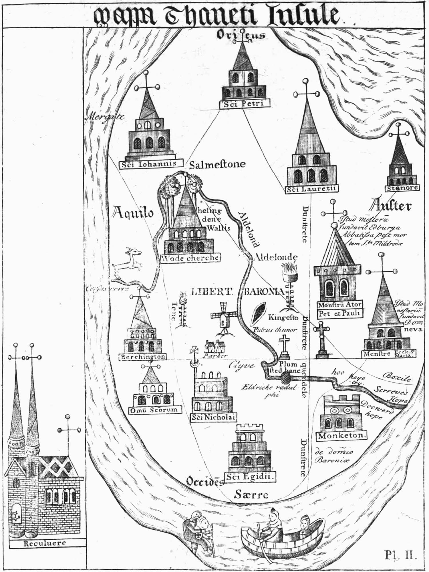 |
Figure 22. Thomas of Almham’s map of the Isle of Thanet, ca 1414, from John Lewis, 'The History and antiquities ecclesiastical and civil, of the Isle of Tenet, in Kent', 1st ed., London, 1723. |
Those heading to Margate from Canterbury would have had to travel over the local roads. A sketch map of the Isle of Thanet by Thomas of Elmham dating to about 1414 shows a trackway leading from Sarre to the church of St John’s and then to Mergate on the coast (Figure 22). The crossing at Sarre was originally by ferry but an Act passed in 1485 allowed for the ferry to be replaced by a bridge.158 It is worth quoting the preamble to the bill as it gives the reasons for building the bridge:
Forasmuch as the Isle of Tenet, in the county of Kent, lying upon the high sea on the east and north parts thereof, and to the river of salt water leading from a place called Northmouth, joining the sea, to a place within the shire called Sarre, and from thence to the town and haven of Sandwich, and so forth to the sea on the west and south parts of the isle, out of time of mind, hath been enclosed and environed with the sea and river; at which place, called Sarre, by all this time, hath been had and used a passage, and a ferry, called Sarre ferry, over the said river, by a ferry boat, out of the isle into the country of the shire of Kent, for all manner of persons, beasts, corn, and other things, to pass and be conveyed at all seasons, to and from the same isle and country; by which same ferry also, when enemies afore this time have arrived, and purposed to have arrived in the isle, the people of the same country lightly have been conveyed and might be conveyed into the isle to resist all such enemies for defence and tuition [protection] of the isle. It is so now that, by change of the course of the sea, which hath fortuned in years late passed, the river at the place called Sarre, where the ferry and passage was had and used, is so swared, [sluggish] grown, and highed with wose, [silted up with ooze, etc.] mud, and sand, that now no ferry or other passage may be there, nor in any other place nigh adjoining and convenient, to or from the isle, by boat or otherwise, but only at high spring floods, and that not passing an hour at a tide, to the great hurt and impoverishing of the possessioners, landholders, owners, and inhabitants of the isle and country, and by likelihood in time of war great jeopardy and fear of loss of the isle, if enemies should fortune to arrive in the same.
The bill allowed the inhabitants of Thanet to build a bridge at Sarre Ferry, ‘of such reasonable length, height, and large space between the arches thereof, that boats and lighters may pass to and fro under the same, at any time hereafter when the water may happen to increase and be sufficient’ for their passage. After completion of the bridge Commissioners were to be appointed who would make provision for repairs and maintenance of the bridge and approaches, paid for by the inhabitants of Thanet.
Major repairs were indeed necessary by 1729 when the bridge had to be closed for repair; forewarning of the expected disruption was given in an advertisement in the local paper:160Whereas the bridge at Saar that doth lead the way into the Island of Thanet being out of repair, is by the Honourable the Commissioners of Sewers ordered to be immediately repaired and sufficiently amended, for the safe passage of cattle, carriages, horses, and passengers over the same, and that in order to the repair of the said bridge, the same will on Monday the 19th day of May instant be uncovered, laid open, and be uncapable to be passed on and over until Friday the 23rd day of this said month of May. This is to give notice thereof to all whom it may concern. And it is desired of those who meet with and read this Advertisement, that they will help to perfect it, by giving notice of the same to others it may concern, that they know or see, and who they think may not happen to see or read this Advertisement.
The bridge is shown on the earliest detailed map of Kent, that of Symonson of 1596. This shows the main road from Canterbury to the Isle of Thanet crossing over the bridge at Sarre, and then following a fairly straight inland route through Monkton and Acol , bypassing Birchington, to reach Margate at the west end of the bay (Figure 5). Symonson’s map shows none of the minor roads, most of which would have been just bridle paths; the first map to include such roads was that of John Harris published in 1717 (Figure 8). Harris’s map shows the main road from Canterbury following the same route as that shown by Symonson, except that the road reaches Margate not at the bay but at a junction with the King’s Highway leading to the church, later to become the High Street. A minor road is also shown, branching off from the main road from Canterbury just beyond the crossing at Sarre, and running through St Nicholas to Birchington and Garlinge to join the King’s Highway at its northern end, close to Margate bay. Other minor roads link Margate to Minster in the west, to Sandwich, to Broadstairs and to Ramsgate. Later maps, such as John Hall’s map of 1777 (Figure 12) show the Canterbury road taking a more inland route beyond Acol to pass by Hengrove and Shotendane to reach Salmstone, where the road turns north to reach the King’s Highway at its southern end near the church. The minor road from Birchington also now takes a more inland course beyond Garlinge to pass through Hartsdown to reach Salmestone where it joins the main Canterbury Road. This realignment of the roads was probably required to improve access to the town and cope with the increased levels of traffic experienced once Margate had become established as a seaside resort. Arthur Rowe suggested that the main road from Canterbury was the ‘winter road’ whereas in the summer coaches followed the minor road via Birchington.161 There was no road to Margate from the west along the coast because of the barrier provided by the Brooks. The road shown on Hall’s map of 1777 from Birchington to Westgate was only a bridle-track ending at the cliff edge near Westbrook Mill, where Royal Crescent now stands; there was no road from Westbrook Mill into Margate.161
The roads in Thanet would have been something of a disappointment to a traveller after the Dover road. A Description of the Isle of Thanet and particularly of the Town of Margate, published in 1763, described what a traveller could expect: ‘The Roads about the islands are rendered so intricate, by means of many short turnings, as to be extremely disagreeable to those who are not well acquainted with them. The inhabitants of Ramsgate from a just sense of the respect due to Strangers, have lately erected Guide-posts in all places of difficulty within their precinct; and I hope the adjacent parishes will not hesitate to follow so truly laudable an example. Nor is this the only inconvenience; for the Bye-roads are by no means fit for quartering carriages. It is but a short time since they have been much used by any others, than those employed in husbandry; but the Land-holders, now finding themselves every where under a necessity of rendering the ways passable, or of having their corn trampled down, are beginning to make improvements of this sort’.162 A description of the roads in 1796 gives a picture of what they must have been like earlier in the century: ‘The roads about this island being originally intended only for carts and waggons, were formerly much neglected, and scarcely passable by the more delicate carriages of convenience or pleasure, but, to the credit of the inhabitants, they have been lately much improved, and are now made so commodious, that although there are no turnpikes, the traveller in Thanet will, without expence, experience all the advantages of that useful institution’.163
There are no records of regular coach services from Thanet to Canterbury until after the holiday trade developed later in the eighteenth century, or of regular waggon or cart services, although there is an advertisement for a regular tilt wagon service from Canterbury to Deal, run by Thomas Beale in 1735:164
Thomas Beale sets out with a Tilt Cart and two horses from his House in Deale to the Bell in Sandwich, and from thence to the Vine in the Fish Market, Canterbury, every Monday and returns on Tuesdays, and will continue to carry passengers or Goods at reasonable rates.
Few, if any, of the inhabitants of Margate were wealthy enough to own their own carriage; whilst documents of the time contain many references to horses, stables, and farmer’s carts there are no references to carriages and carriage houses. An inventory of 1732 of the goods of Edward Jarvis, one of the local doctors, included a stable containing one horse, but no mention of a carriage.166 The great and the good arriving by sea in Margate ensured that their own coaches would be waiting there for them (Chapter 2). In 1718 ‘A Coach and Six Horses are gone to Margate to meet the Earl Cardogan, who is hourly expected there from Holland’ and in October 1720 ‘Tuesday Morning several of the King’s Coaches and Carriages set out for Margate, to wait his Arrival from Holland’.167,168
Most journeys, if not on foot or in a farmer’s cart, were on horseback. The national survey of inns undertaken in 1686 found that there was stabling for 40 traveller’s horses in the town’s inns, the number increasing to 62 in 1756.100,101 An advertisement for the White Hart Inn in 1729 assured ‘all Gentlemen and others’ that they ‘may be furnished with good Horses, at reasonable Rates’.169 Carriages are not mentioned until 1747 when an advertisement for the Posthouse at Margate mentions ‘very good . . . stabling and coach-rooms’.111 Pier Accounts and the Accounts of the Overseers of the Poor include many charges for the hire of horses but none for the hire of carriages.39,51 In 1686 the Deputy and one of the Pier Wardens travelled to London and charged £4 1s ‘for 11 days for our horses and our selves’ and a Pier Warden charged £1 4s for ‘2 horses hire to London and Maidstone’. There are occasional references in the Overseers’ Accounts to the hire of carts, as in 1733 when they moved a woman and her child out of the parish and paid 1s 3d ‘for a cart to carry the woman and child aboard of the hoy, and other help’.
Someone wishing to send a small package would have been able to make use of the newsmen who distributed the local Canterbury paper, the Kentish Post and Canterbury Newsletter. The paper had been established in 1717 and its agents, the newsmen, each had a route, radiating out from Canterbury which they followed to distribute the paper, together with parcels and patent medicines, which were much in demand at the time. The routes of two of these newsmen are known, one going from Canterbury to Barham, Elham, Folkestone, Hythe, Dymchurch, Romney and Lydd, and the other from Canterbury to Faversham, Sittingbourne, Milton, Chatham and Rochester.165 We also know that there was another route including Dover and Margate as in 1733 the overseers of the poor at Margate paid 5s 2d ‘for a warrant from Dover by the News-man’.39 Paying a newsman was a cheaper way of getting a warrant from Dover to Margate than sending a man especially to Dover to collect it, and the service was reasonably frequent, as the Kentish Post and Canterbury Newsletter was published twice weekly.
Communications: The Hoys
The importance of the harbour at Margate for the import and export of goods will be described in the following chapter. The speed and low cost of moving things by sea made the hoy a popular mode of transport for small items as well as for bulk cargos such as corn and coal. Hoymen would often carry parcels from Margate to London, acting as a ‘common carrier’. The parcels would be put onto the hoy without any proper inspection, convenient for anyone trying to move smuggled goods landed at Margate up to London, as found to his cost by Roger Laming, a local hoyman, in 1798 (Chapter 5). Hoys were also much used for passenger traffic; by the early eighteenth century the open holds of the old hoys had been ‘decked-in’, increasing the comfort of the journey.170 In 1637 John Taylor provided a list of ships sailing from London ‘to carry passegers and goods to the towns of England’ and reported that ‘a Hoigh from Rochester Margate in Kent, or Feversham and Maydston doth come to St Katherines Dock’.171 By 1710 there was a weekly hoy service between Margate and London.2,172 The hoys were used by the ‘middling-sort’ as well as by the poor; in 1635 Peter Criche, the vicar of St John’s, and his parish clerk were drowned on a voyage to London in a hoy.1 In 1731 a hoy with 30 passengers was reported lost: ‘On Tuesday last a Hoy, bound to Margate in Kent, turning to windward under a hard gale of wind, was unhappily overset between Eriff and Woolwich, by which accident about 30 passengers were all lost’.173 Hoys were also used by the Overseers of the Poor to transport seriously ill people for treatment in one of the London hospitals (Chapter 4).
Communications: The Post Office
The history of the post office in Kent has been told by Brian Austen in his English Provincial Posts and much of what follows is based on his book.105 The beginnings of the postal system can be dated to Henry VIII’s appointment of Sir Brian Tuke as the first Master of the Post. Tuke established a permanent post route along the Dover Road, dividing the road into stages with postmasters at each stage to provide horses for the King’s messengers. Merchants and others were encouraged to take advantage of these royal mails, the recipient paying for the service at a fixed sum per sheet of paper, charged according to the distance travelled. In 1632 Thomas Witherings, a London merchant, took over responsibility for the foreign mails, increasing their speed and frequency. Under his management it was intended that letters leaving London by 6 pm should reach Dover early next day ‘that ther may be sufficient day light for passage over sea the same day’. The postmasters along the road, mostly innkeepers, agreed that they would have ‘sufficient horses and messingers alwaies in redinesse, to go forth with the pacquets with out aine delay and to deliver them from stage to stage within the compasse of an hour & half for ene stage’.105
Speeds increased from about sixteen miles a day, achieved by foot post, to about 120 miles a day. In 1635 Withering also took over the inland posts, converting them to the system in operation on the Dover road. Rates for a letter consisting of a single sheet of paper were 2d up to 80 miles, 4d up to 140 miles, 6d over a 140 miles, and 8d to Scotland. Between London and Dover there were postmasters at Dartford, Gravesend, Rochester, Sittingbourne and Canterbury; there were also postmasters at Deal and Sandwich, probably to sends orders to and from any ships sheltering in the anchorage of the Downs. Postmasters were not directly employed by the Post Office but received a shilling a day for their services, except for the postmaster at Gravesend who received only sixpence, and 2½d per mile for the hire of horses. Postmasters were also granted sole right to provide horses for travellers wishing to travel post along the road.
It is not known when a postmaster was first appointed at Margate but it must have been before 1660 as in that year John Glover was sacked as postmaster because of his close contacts with ‘disaffected persons’, as described earlier in this Chapter.87 A list of stages on the Dover Road dating from 1667 includes Deal, Sandwich and Margate, the mail between Canterbury and Deal going via Sandwich, with letters for Margate being left at Sandwich to be taken on by a separate post boy.105 The service was not very good, as is clear from a letter from John Glover to Sir Joseph Williamson in London in 1672:93
May 11, 2 pm 1672. About sunrise this morning the whole Dutch fleet came in upon the Foreland, and lay off and on Margate, there most of the forenoon with their sails haled up. They were so near in that we could see their hulks very plain, but now they are beating off to sea again. I must send this to the post house at Sandwich, for no post goes from us, except Tuesdays and Fridays.
The postmaster at Deal appears to have been in charge of the post offices at Sandwich and Margate; in October 1674 he was asked to settle the Sandwich and Margate offices;105
I heare from Sandwich, that Mr Finch is gone into ye Contrey quits his Imployment soe doth his agents in ye Isle of Thanet, and without giveing me the least notice . . . I must desire your assistance ernestly desiring you to go imediately to Sandwich and Thanet, and settle ye office in both places.
The postmaster at Margate in 1667 was Richard Langley, and Langley continued in post until 1672 when he died. In October 1674 ‘Mr Laming’ was appointed postmaster at Margate, showing once again the importance of this family in the early history of the town.105
However good the postal service at Margate, many would ask a local sailor to carry their letters to London for them on one of the hoys, at a cost considerably less than that charged by the post office. On his appointment, Mr Laming was instructed ‘to hinder the Hoys, wch Carry abundance of Letters from that Place’.105 Another problem was that a significant part of the income of a postmaster came from his monopoly on providing horses for those travelling post, an income threatened when others also provided post horses. In February 1678 Mr Laming was advised to take legal action against those illegally hiring out post horses.105
A list of Margate postmasters from 1691 to 1790 is given in Appendix IV. Payments in the accounts of the Overseers of the Poor suggest that Paul Hart, the postmaster from 1691-1709, was an innkeeper who, sadly, fell on hard times at the end of his life, for, in 1715, the Overseers paid 2s ‘to Paul Hart in need’.35 The next postmaster was Henry Savage, probably related to Mary Savage, wife of John Savage, the owner of the White Hart Inn in 1701.35 Following the death of John Savage in 1710, Mary Savage married Edward Constant, who became Margate postmaster in 1719.
Communications: The Town Crier
In a small town like Margate, gossip and rumour would keep people informed about their neighbours’ business, but for more formal matters there was the town crier, or bellman. As described in Chapter 5 the bellman would help in raising a hue and cry to catch a criminal, would let people know when something had been stolen, and so help in its recovery, and would let people know about articles that had been lost. The bellman would also broadcast the news of local events such as entertainments and auctions. A particularly important task was to announce when goods such as coal, wood, salt, butter or cheese had arrived in the harbour, as these had to be offered for sale to the inhabitants of the town according to the orders governing the Pier and Harbour (Chapter 2). The first town crier for whom we have a name is Abraham Pond who, in 1666, was paid an unknown sum ‘for going to Lidden to fetch the Barley wee destrained and crying of it’, that is, letting the inhabitants know that some barley was available for purchase.35 Pond later became an innkeeper and was replaced as town crier by Thomas Bishop who, in 1702, was paid 4d ‘for crying Widd Baylyes Goods’.35 A later town crier was William Birch, who died in 1744, aged 77; Birch was also the Parish Beadle.39 In 1735 the parish paid £2 2s 6d for a coat and a hat for William Birch, so that he must have been a resplendent figure in the town.39